Jennings geodata
Jennings (Florida) is a populated place; located in United States in America/New_York (GMT-4) time zone. With population of 870 people, there are 17201 cities with bigger population in this country. Compared to other cities in United States, 91.5% of cities are located further ↑North; 61.7% of cities are located further ←West and 79.9% of cities have higher elevation than Jennings. Note1


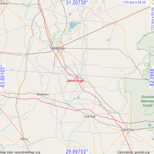
Jennings GPS coordinates[2]
30° 36' 14.76" North, 83° 5' 52.512" West
| Map corner | latitude | longitude |
|---|---|---|
| Upper-left | 31.20739°, | -83.80105° |
| Center: | 30.6041°, | -83.09792° |
| Lower-right: | 29.99703°, | -82.3948° |
| Map W x H: | 134.6×134.6 km | = 83.6×83.6mi |
| max Lat: | 71.29058° ⇑91.5% North |
| Jennings: | 30.6041° |
| min Lat: | ⇓8.5% South 19.06759° |
| min Long | Jennings | max Long |
| -171.73463° | -83.09792° | -66.98998° |
| W 61.7%⇐ | ⇒38.3% E |
Elevation
Elevation of Jennings is 47 m = 154 ft, and this is 247.8 m = 813 ft below average elevation for this country.
| Max E: |
3189 m = 10463 ft | 79.9% |
| Avg. | 294.8 m = 967 ft | |
| Jennings | 47 m = 154 ft | |
Min E: |
-60 m = -197 ft | 20.1% |
See also: United States elevation on elevation.city.
Geographical zone
Jennings is located in North temperate zone (between Tropic of Cancer and the Arctic Circle). Distance of this Northern Tropic circle is 796.9 km =495.2 mi to South.| Distance of | km | miles | from Jennings |
|---|---|---|---|
| North Pole | 6604.2 | 4103.7 | to North |
| Arctic Circle | 3998.3 | 2484.4 | to North |
| Tropic Cancer | 796.9 | 495.2 | to South |
| Equator | 3402.9 | 2114.5 | to South |


Nearby cities:
15 places around Jennings: (largest is in red/bold)
• Dasher
19.8 km =12.3 mi,  323°
323°
• Greenville
53.1 km =33 mi,  253°
253°
• Hahira
50.4 km =31.3 mi,  328°
328°
• Jasper
17.2 km =10.7 mi,  123°
123°
• Lake Park
11.7 km =7.3 mi, 318°
• Lakeland
48.6 km =30.2 mi,  2°
2°
• Live Oak
36.1 km =22.4 mi,  162°
162°
• Madison
33.7 km =20.9 mi,  243°
243°
• Moody A F B
43.1 km =26.8 mi,  344°
344°
• Quitman
48.5 km =30.1 mi,  294°
294°
• Remerton
33.5 km =20.8 mi, 322°
• Statenville
12.9 km =8 mi,  31°
31°
• Valdosta
30.9 km =19.2 mi, 325°
• Wellborn
49.3 km =30.6 mi,  147°
147°
• White Springs
44.6 km =27.7 mi,  133°
133°
Sources, notices
• [Note1] Compared only with cities in United States existing in our database
• [Src1] Map data: © OpenStreetMap contributors (CC-BY-SA)
• [Src2] Other city data from geonames.org with taken over terms of usage.
• [Src3] Geographical zone / Annual Mean Temperature by Robert A. Rohde @ Wikipedia
