Greenville geodata
Greenville (Florida) is a populated place; located in United States in America/New_York (GMT-4) time zone. With population of 803 people, there are 17786 cities with bigger population in this country. Compared to other cities in United States, 91.9% of cities are located further ↑North; 60.3% of cities are located further ←West and 82.9% of cities have higher elevation than Greenville. Note1


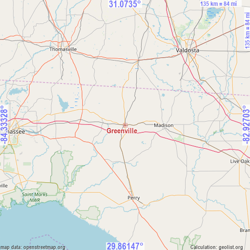
Greenville GPS coordinates[2]
30° 28' 9.732" North, 83° 37' 48.54" West
| Map corner | latitude | longitude |
|---|---|---|
| Upper-left | 31.0735°, | -84.33328° |
| Center: | 30.46937°, | -83.63015° |
| Lower-right: | 29.86147°, | -82.92703° |
| Map W x H: | 134.8×134.8 km | = 83.8×83.8mi |
| max Lat: | 71.29058° ⇑91.9% North |
| Greenville: | 30.46937° |
| min Lat: | ⇓8.1% South 19.06759° |
| min Long | Greenville | max Long |
| -171.73463° | -83.63015° | -66.98998° |
| W 60.3%⇐ | ⇒39.7% E |
Elevation
Elevation of Greenville is 35 m = 115 ft, and this is 259.8 m = 852 ft below average elevation for this country.
| Max E: |
3189 m = 10463 ft | 82.9% |
| Avg. | 294.8 m = 967 ft | |
| Greenville | 35 m = 115 ft | |
Min E: |
-60 m = -197 ft | 17.1% |
See also: United States elevation on elevation.city.
Geographical zone
Greenville is located in North temperate zone (between Tropic of Cancer and the Arctic Circle). Distance of this Northern Tropic circle is 782 km =485.9 mi to South.| Distance of | km | miles | from Greenville |
|---|---|---|---|
| North Pole | 6619.2 | 4113 | to North |
| Arctic Circle | 4013.3 | 2493.7 | to North |
| Tropic Cancer | 782 | 485.9 | to South |
| Equator | 3387.9 | 2105.1 | to South |


Nearby cities:
15 places around Greenville: (largest is in red/bold)
• Boston
39 km =24.2 mi,  336°
336°
• Dasher
49.9 km =31 mi,  51°
51°
• Jennings
53.1 km =33 mi,  73°
73°
• Lake Park
49.2 km =30.6 mi,  61°
61°
• Madison
20.8 km =12.9 mi,  89°
89°
• Monticello
24.6 km =15.3 mi,  290°
290°
• Morven
54 km =33.6 mi,  13°
13°
• Pavo
55.5 km =34.5 mi,  349°
349°
• Perry
39.4 km =24.5 mi,  173°
173°
• Quitman
35.7 km =22.2 mi, 10°
• Remerton
51.7 km =32.1 mi,  36°
36°
• Tallahassee
62.5 km =38.8 mi,  266°
266°
• Thomasville
52.7 km =32.7 mi,  320°
320°
• Valdosta
52.5 km =32.6 mi, 39°
• Woodville
61.7 km =38.3 mi,  253°
253°
Sources, notices
• [Note1] Compared only with cities in United States existing in our database
• [Src1] Map data: © OpenStreetMap contributors (CC-BY-SA)
• [Src2] Other city data from geonames.org with taken over terms of usage.
• [Src3] Geographical zone / Annual Mean Temperature by Robert A. Rohde @ Wikipedia
