Lakeland geodata
Lakeland (Georgia) is a seat of a second-order administrative division; located in United States in America/New_York (GMT-4) time zone. With population of 3,322 people, there are 9107 cities with bigger population in this country. Compared to other cities in United States, 90.7% of cities are located further ↑North; 61.8% of cities are located further ←West and 76.3% of cities have higher elevation than Lakeland. Note1


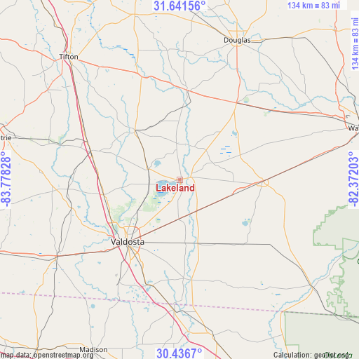
Lakeland GPS coordinates[2]
31° 2' 27.744" North, 83° 4' 30.54" West
| Map corner | latitude | longitude |
|---|---|---|
| Upper-left | 31.64156°, | -83.77828° |
| Center: | 31.04104°, | -83.07515° |
| Lower-right: | 30.4367°, | -82.37203° |
| Map W x H: | 134×134 km | = 83.3×83.3mi |
| max Lat: | 71.29058° ⇑90.7% North |
| Lakeland: | 31.04104° |
| min Lat: | ⇓9.3% South 19.06759° |
| min Long | Lakeland | max Long |
| -171.73463° | -83.07515° | -66.98998° |
| W 61.8%⇐ | ⇒38.2% E |
Elevation
Elevation of Lakeland is 64 m = 210 ft, and this is 230.8 m = 757 ft below average elevation for this country.
| Max E: |
3189 m = 10463 ft | 76.3% |
| Avg. | 294.8 m = 967 ft | |
| Lakeland | 64 m = 210 ft | |
Min E: |
-60 m = -197 ft | 23.7% |
See also: United States elevation on elevation.city.
Geographical zone
Lakeland is located in North temperate zone (between Tropic of Cancer and the Arctic Circle). Distance of this Northern Tropic circle is 845.5 km =525.4 mi to South.| Distance of | km | miles | from Lakeland |
|---|---|---|---|
| North Pole | 6555.6 | 4073.5 | to North |
| Arctic Circle | 3949.7 | 2454.2 | to North |
| Tropic Cancer | 845.5 | 525.4 | to South |
| Equator | 3451.4 | 2144.6 | to South |


Nearby cities:
15 places around Lakeland: (largest is in red/bold)
• Adel
34.9 km =21.7 mi,  287°
287°
• Alapaha
40.8 km =25.4 mi,  339°
339°
• Dasher
35.5 km =22.1 mi,  203°
203°
• Hahira
28.9 km =18 mi,  258°
258°
• Homerville
31.3 km =19.4 mi,  90°
90°
• Lake Park
41.1 km =25.5 mi,  194°
194°
• Moody A F B
15.2 km =9.4 mi,  242°
242°
• Nashville
24.9 km =15.5 mi,  318°
318°
• Pearson
35.5 km =22.1 mi,  36°
36°
• Ray City
12.4 km =7.7 mi, 287°
• Remerton
31.4 km =19.5 mi,  225°
225°
• Sparks
37.2 km =23.1 mi, 292°
• Statenville
37.8 km =23.5 mi,  173°
173°
• Valdosta
30.3 km =18.8 mi,  220°
220°
• Willacoochee
33.4 km =20.8 mi,  4°
4°
Sources, notices
• [Note1] Compared only with cities in United States existing in our database
• [Src1] Map data: © OpenStreetMap contributors (CC-BY-SA)
• [Src2] Other city data from geonames.org with taken over terms of usage.
• [Src3] Geographical zone / Annual Mean Temperature by Robert A. Rohde @ Wikipedia
