Arabi geodata
Arabi (Georgia) is a populated place; located in United States in America/New_York (GMT-4) time zone. With population of 563 people, there are 20120 cities with bigger population in this country. Compared to other cities in United States, 88.9% of cities are located further ↑North; 60% of cities are located further ←West and 62.6% of cities have higher elevation than Arabi. Note1


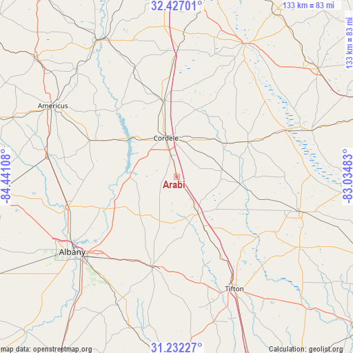
Arabi GPS coordinates[2]
31° 49' 53.652" North, 83° 44' 16.62" West
| Map corner | latitude | longitude |
|---|---|---|
| Upper-left | 32.42701°, | -84.44108° |
| Center: | 31.83157°, | -83.73795° |
| Lower-right: | 31.23227°, | -83.03483° |
| Map W x H: | 132.8×132.8 km | = 82.5×82.5mi |
| max Lat: | 71.29058° ⇑88.9% North |
| Arabi: | 31.83157° |
| min Lat: | ⇓11.1% South 19.06759° |
| min Long | Arabi | max Long |
| -171.73463° | -83.73795° | -66.98998° |
| W 60%⇐ | ⇒40% E |
Elevation
Elevation of Arabi is 141 m = 463 ft, and this is 153.8 m = 505 ft below average elevation for this country.
| Max E: |
3189 m = 10463 ft | 62.6% |
| Avg. | 294.8 m = 967 ft | |
| Arabi | 141 m = 463 ft | |
Min E: |
-60 m = -197 ft | 37.4% |
See also: United States elevation on elevation.city.
Geographical zone
Arabi is located in North temperate zone (between Tropic of Cancer and the Arctic Circle). Distance of this Northern Tropic circle is 933.4 km =580 mi to South.| Distance of | km | miles | from Arabi |
|---|---|---|---|
| North Pole | 6467.7 | 4018.8 | to North |
| Arctic Circle | 3861.8 | 2399.6 | to North |
| Tropic Cancer | 933.4 | 580 | to South |
| Equator | 3539.3 | 2199.2 | to South |


Nearby cities:
15 places around Arabi: (largest is in red/bold)
• Abbeville
44.4 km =27.6 mi,  66°
66°
• Ashburn
16.1 km =10 mi,  150°
150°
• Byromville
44.2 km =27.5 mi,  338°
338°
• Cordele
15.3 km =9.5 mi, 344°
• Fitzgerald
47.7 km =29.6 mi,  105°
105°
• Leesburg
42.4 km =26.3 mi,  254°
254°
• Pineview
38.2 km =23.7 mi,  35°
35°
• Poulan
35.7 km =22.2 mi,  187°
187°
• Rochelle
29.7 km =18.5 mi,  63°
63°
• Sycamore
19.9 km =12.4 mi, 151°
• Sylvester
34.7 km =21.6 mi,  195°
195°
• Tifton
47.6 km =29.6 mi, 152°
• Ty Ty
40.9 km =25.4 mi,  167°
167°
• Unadilla
47.8 km =29.7 mi,  0°
0°
• Vienna
29.4 km =18.3 mi,  349°
349°
Sources, notices
• [Note1] Compared only with cities in United States existing in our database
• [Src1] Map data: © OpenStreetMap contributors (CC-BY-SA)
• [Src2] Other city data from geonames.org with taken over terms of usage.
• [Src3] Geographical zone / Annual Mean Temperature by Robert A. Rohde @ Wikipedia
