Sylvester geodata
Sylvester (Georgia) is a seat of a second-order administrative division; located in United States in America/New_York (GMT-4) time zone. With population of 6,049 people, there are 6368 cities with bigger population in this country. Compared to other cities in United States, 89.6% of cities are located further ↑North; 59.7% of cities are located further ←West and 65.2% of cities have higher elevation than Sylvester. Note1


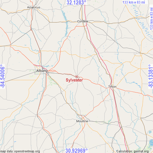
Sylvester GPS coordinates[2]
31° 31' 51.312" North, 83° 50' 12.948" West
| Map corner | latitude | longitude |
|---|---|---|
| Upper-left | 32.1283°, | -84.54006° |
| Center: | 31.53092°, | -83.83693° |
| Lower-right: | 30.92969°, | -83.13381° |
| Map W x H: | 133.3×133.3 km | = 82.8×82.8mi |
| max Lat: | 71.29058° ⇑89.6% North |
| Sylvester: | 31.53092° |
| min Lat: | ⇓10.4% South 19.06759° |
| min Long | Sylvester | max Long |
| -171.73463° | -83.83693° | -66.98998° |
| W 59.7%⇐ | ⇒40.3% E |
Elevation
Elevation of Sylvester is 127 m = 417 ft, and this is 167.8 m = 551 ft below average elevation for this country.
| Max E: |
3189 m = 10463 ft | 65.2% |
| Avg. | 294.8 m = 967 ft | |
| Sylvester | 127 m = 417 ft | |
Min E: |
-60 m = -197 ft | 34.8% |
See also: United States elevation on elevation.city.
Geographical zone
Sylvester is located in North temperate zone (between Tropic of Cancer and the Arctic Circle). Distance of this Northern Tropic circle is 900 km =559.2 mi to South.| Distance of | km | miles | from Sylvester |
|---|---|---|---|
| North Pole | 6501.2 | 4039.7 | to North |
| Arctic Circle | 3895.3 | 2420.4 | to North |
| Tropic Cancer | 900 | 559.2 | to South |
| Equator | 3505.9 | 2178.5 | to South |


Nearby cities:
15 places around Sylvester: (largest is in red/bold)
• Albany
30.7 km =19.1 mi,  279°
279°
• Arabi
34.7 km =21.6 mi,  15°
15°
• Ashburn
26.1 km =16.2 mi,  41°
41°
• Baconton
35 km =21.7 mi,  241°
241°
• Doerun
24.7 km =15.3 mi,  197°
197°
• Leesburg
38.7 km =24 mi,  305°
305°
• Norman Park
32.4 km =20.1 mi,  153°
153°
• Omega
31.3 km =19.4 mi,  132°
132°
• Phillipsburg
31.8 km =19.8 mi,  108°
108°
• Poulan
5.1 km =3.2 mi, 113°
• Putney
27.5 km =17.1 mi,  255°
255°
• Sycamore
24.7 km =15.3 mi,  49°
49°
• Tifton
32.4 km =20.1 mi, 106°
• Ty Ty
19.2 km =11.9 mi, 110°
• Unionville
32.8 km =20.4 mi, 108°
Sources, notices
• [Note1] Compared only with cities in United States existing in our database
• [Src1] Map data: © OpenStreetMap contributors (CC-BY-SA)
• [Src2] Other city data from geonames.org with taken over terms of usage.
• [Src3] Geographical zone / Annual Mean Temperature by Robert A. Rohde @ Wikipedia
