Leesburg geodata
Leesburg (Georgia) is a seat of a second-order administrative division; located in United States in America/New_York (GMT-4) time zone. With population of 2,983 people, there are 9664 cities with bigger population in this country. Compared to other cities in United States, 89.1% of cities are located further ↑North; 58.7% of cities are located further ←West and 72.8% of cities have higher elevation than Leesburg. Note1


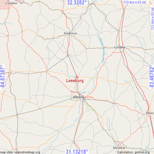
Leesburg GPS coordinates[2]
31° 43' 55.632" North, 84° 10' 14.664" West
| Map corner | latitude | longitude |
|---|---|---|
| Upper-left | 32.3282°, | -84.87387° |
| Center: | 31.73212°, | -84.17074° |
| Lower-right: | 31.13218°, | -83.46762° |
| Map W x H: | 133×133 km | = 82.6×82.6mi |
| max Lat: | 71.29058° ⇑89.1% North |
| Leesburg: | 31.73212° |
| min Lat: | ⇓10.9% South 19.06759° |
| min Long | Leesburg | max Long |
| -171.73463° | -84.17074° | -66.98998° |
| W 58.7%⇐ | ⇒41.3% E |
Elevation
Elevation of Leesburg is 84 m = 276 ft, and this is 210.8 m = 692 ft below average elevation for this country.
| Max E: |
3189 m = 10463 ft | 72.8% |
| Avg. | 294.8 m = 967 ft | |
| Leesburg | 84 m = 276 ft | |
Min E: |
-60 m = -197 ft | 27.2% |
See also: United States elevation on elevation.city.
Geographical zone
Leesburg is located in North temperate zone (between Tropic of Cancer and the Arctic Circle). Distance of this Northern Tropic circle is 922.4 km =573.2 mi to South.| Distance of | km | miles | from Leesburg |
|---|---|---|---|
| North Pole | 6478.8 | 4025.7 | to North |
| Arctic Circle | 3872.9 | 2406.5 | to North |
| Tropic Cancer | 922.4 | 573.2 | to South |
| Equator | 3528.3 | 2192.4 | to South |


Nearby cities:
15 places around Leesburg: (largest is in red/bold)
• Albany
17.1 km =10.6 mi,  175°
175°
• Americus
38.3 km =23.8 mi,  351°
351°
• Arabi
42.4 km =26.3 mi,  74°
74°
• Ashburn
49 km =30.4 mi,  93°
93°
• Baconton
39.2 km =24.4 mi, 178°
• Cordele
44.8 km =27.8 mi,  54°
54°
• Dawson
26.6 km =16.5 mi,  280°
280°
• Leary
42.5 km =26.4 mi,  229°
229°
• Morgan
46 km =28.6 mi,  241°
241°
• Plains
39.6 km =24.6 mi,  328°
328°
• Poulan
43.7 km =27.2 mi,  123°
123°
• Putney
29.6 km =18.4 mi,  170°
170°
• Shellman
42.1 km =26.2 mi,  273°
273°
• Smithville
20.2 km =12.6 mi,  337°
337°
• Sylvester
38.7 km =24 mi,  125°
125°
Sources, notices
• [Note1] Compared only with cities in United States existing in our database
• [Src1] Map data: © OpenStreetMap contributors (CC-BY-SA)
• [Src2] Other city data from geonames.org with taken over terms of usage.
• [Src3] Geographical zone / Annual Mean Temperature by Robert A. Rohde @ Wikipedia
