Cordele geodata
Cordele (Georgia) is a seat of a second-order administrative division; located in United States in America/New_York (GMT-4) time zone. With population of 10,943 people, there are 4191 cities with bigger population in this country. Compared to other cities in United States, 88.7% of cities are located further ↑North; 59.9% of cities are located further ←West and 70.8% of cities have higher elevation than Cordele. Note1


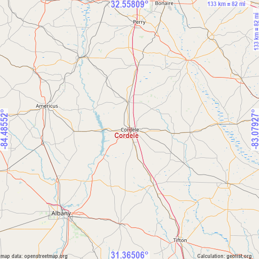
Cordele GPS coordinates[2]
31° 57' 48.636" North, 83° 46' 56.604" West
| Map corner | latitude | longitude |
|---|---|---|
| Upper-left | 32.55809°, | -84.48552° |
| Center: | 31.96351°, | -83.78239° |
| Lower-right: | 31.36506°, | -83.07927° |
| Map W x H: | 132.7×132.7 km | = 82.5×82.5mi |
| max Lat: | 71.29058° ⇑88.7% North |
| Cordele: | 31.96351° |
| min Lat: | ⇓11.3% South 19.06759° |
| min Long | Cordele | max Long |
| -171.73463° | -83.78239° | -66.98998° |
| W 59.9%⇐ | ⇒40.1% E |
Elevation
Elevation of Cordele is 96 m = 315 ft, and this is 198.8 m = 652 ft below average elevation for this country.
| Max E: |
3189 m = 10463 ft | 70.8% |
| Avg. | 294.8 m = 967 ft | |
| Cordele | 96 m = 315 ft | |
Min E: |
-60 m = -197 ft | 29.2% |
See also: United States elevation on elevation.city.
Geographical zone
Cordele is located in North temperate zone (between Tropic of Cancer and the Arctic Circle). Distance of this Northern Tropic circle is 948.1 km =589.1 mi to South.| Distance of | km | miles | from Cordele |
|---|---|---|---|
| North Pole | 6453.1 | 4009.8 | to North |
| Arctic Circle | 3847.2 | 2390.5 | to North |
| Tropic Cancer | 948.1 | 589.1 | to South |
| Equator | 3554 | 2208.4 | to South |


Nearby cities:
15 places around Cordele: (largest is in red/bold)
• Abbeville
45 km =28 mi,  85°
85°
• Americus
44.1 km =27.4 mi,  285°
285°
• Arabi
15.3 km =9.5 mi,  164°
164°
• Ashburn
31.1 km =19.3 mi, 156°
• Byromville
29.1 km =18.1 mi,  335°
335°
• Hawkinsville
46.1 km =28.6 mi,  39°
39°
• Leesburg
44.8 km =27.8 mi,  234°
234°
• Montezuma
44.4 km =27.6 mi,  328°
328°
• Oglethorpe
45.1 km =28 mi,  324°
324°
• Pineview
31.1 km =19.3 mi,  58°
58°
• Rochelle
30.8 km =19.1 mi, 92°
• Smithville
44.9 km =27.9 mi,  261°
261°
• Sycamore
34.9 km =21.7 mi, 156°
• Unadilla
33.4 km =20.8 mi,  7°
7°
• Vienna
14.3 km =8.9 mi,  355°
355°
Sources, notices
• [Note1] Compared only with cities in United States existing in our database
• [Src1] Map data: © OpenStreetMap contributors (CC-BY-SA)
• [Src2] Other city data from geonames.org with taken over terms of usage.
• [Src3] Geographical zone / Annual Mean Temperature by Robert A. Rohde @ Wikipedia
