Dudley geodata
Dudley (Georgia) is a populated place; located in United States in America/New_York (GMT-4) time zone. With population of 570 people, there are 20030 cities with bigger population in this country. Compared to other cities in United States, 86.9% of cities are located further ↑North; 61.8% of cities are located further ←West and 69.1% of cities have higher elevation than Dudley. Note1


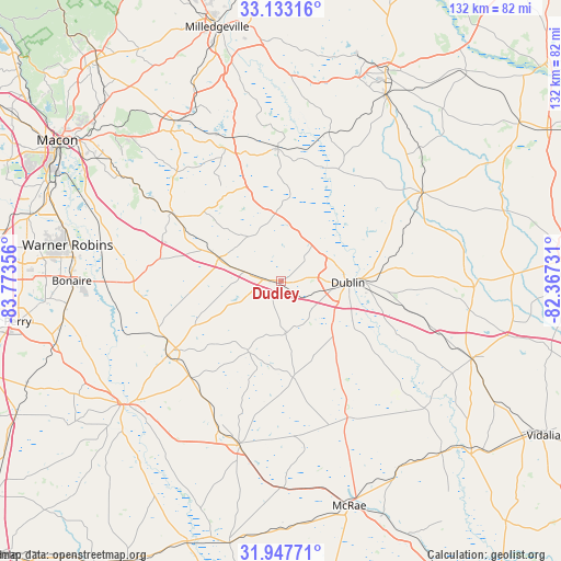
Dudley GPS coordinates[2]
32° 32' 32.604" North, 83° 4' 13.548" West
| Map corner | latitude | longitude |
|---|---|---|
| Upper-left | 33.13316°, | -83.77356° |
| Center: | 32.54239°, | -83.07043° |
| Lower-right: | 31.94771°, | -82.36731° |
| Map W x H: | 131.8×131.8 km | = 81.9×81.9mi |
| max Lat: | 71.29058° ⇑86.9% North |
| Dudley: | 32.54239° |
| min Lat: | ⇓13.1% South 19.06759° |
| min Long | Dudley | max Long |
| -171.73463° | -83.07043° | -66.98998° |
| W 61.8%⇐ | ⇒38.2% E |
Elevation
Elevation of Dudley is 106 m = 348 ft, and this is 188.8 m = 619 ft below average elevation for this country.
| Max E: |
3189 m = 10463 ft | 69.1% |
| Avg. | 294.8 m = 967 ft | |
| Dudley | 106 m = 348 ft | |
Min E: |
-60 m = -197 ft | 30.9% |
See also: United States elevation on elevation.city.
Geographical zone
Dudley is located in North temperate zone (between Tropic of Cancer and the Arctic Circle). Distance of this Northern Tropic circle is 1012.5 km =629.1 mi to South.| Distance of | km | miles | from Dudley |
|---|---|---|---|
| North Pole | 6388.7 | 3969.8 | to North |
| Arctic Circle | 3782.8 | 2350.5 | to North |
| Tropic Cancer | 1012.5 | 629.1 | to South |
| Equator | 3618.4 | 2248.4 | to South |


Nearby cities:
15 places around Dudley: (largest is in red/bold)
• Adrian
45.1 km =28 mi,  91°
91°
• Cadwell
22.7 km =14.1 mi,  173°
173°
• Chester
18.2 km =11.3 mi,  205°
205°
• Cochran
31.8 km =19.8 mi,  237°
237°
• Dexter
12.3 km =7.6 mi,  175°
175°
• Dublin
15.6 km =9.7 mi, 90°
• East Dublin
18.6 km =11.6 mi, 88°
• Eastman
39.6 km =24.6 mi,  194°
194°
• Gordon
45 km =28 mi,  327°
327°
• Hawkinsville
47.4 km =29.5 mi,  232°
232°
• Irwinton
31.4 km =19.5 mi,  342°
342°
• Ivey
45.5 km =28.3 mi, 333°
• Jeffersonville
30.5 km =19 mi,  301°
301°
• McIntyre
35.6 km =22.1 mi, 341°
• Wrightsville
38.9 km =24.2 mi,  57°
57°
Sources, notices
• [Note1] Compared only with cities in United States existing in our database
• [Src1] Map data: © OpenStreetMap contributors (CC-BY-SA)
• [Src2] Other city data from geonames.org with taken over terms of usage.
• [Src3] Geographical zone / Annual Mean Temperature by Robert A. Rohde @ Wikipedia
