Irwinton geodata
Irwinton (Georgia) is a seat of a second-order administrative division; located in United States in America/New_York (GMT-4) time zone. With population of 562 people, there are 20130 cities with bigger population in this country. Compared to other cities in United States, 85.9% of cities are located further ↑North; 61.6% of cities are located further ←West and 63.7% of cities have higher elevation than Irwinton. Note1


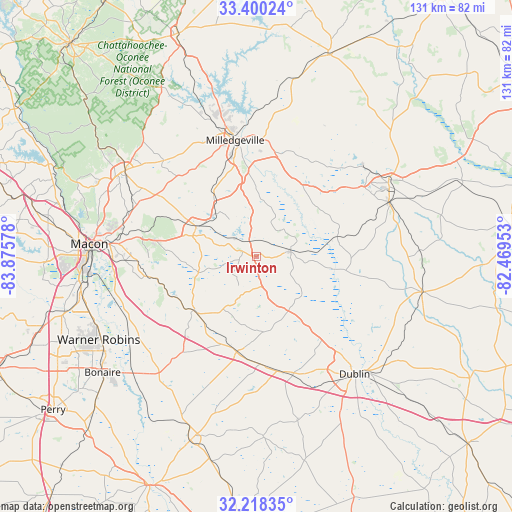
Irwinton GPS coordinates[2]
32° 48' 40.536" North, 83° 10' 21.54" West
| Map corner | latitude | longitude |
|---|---|---|
| Upper-left | 33.40024°, | -83.87578° |
| Center: | 32.81126°, | -83.17265° |
| Lower-right: | 32.21835°, | -82.46953° |
| Map W x H: | 131.4×131.4 km | = 81.6×81.6mi |
| max Lat: | 71.29058° ⇑85.9% North |
| Irwinton: | 32.81126° |
| min Lat: | ⇓14.1% South 19.06759° |
| min Long | Irwinton | max Long |
| -171.73463° | -83.17265° | -66.98998° |
| W 61.6%⇐ | ⇒38.4% E |
Elevation
Elevation of Irwinton is 135 m = 443 ft, and this is 159.8 m = 524 ft below average elevation for this country.
| Max E: |
3189 m = 10463 ft | 63.7% |
| Avg. | 294.8 m = 967 ft | |
| Irwinton | 135 m = 443 ft | |
Min E: |
-60 m = -197 ft | 36.3% |
See also: United States elevation on elevation.city.
Geographical zone
Irwinton is located in North temperate zone (between Tropic of Cancer and the Arctic Circle). Distance of this Northern Tropic circle is 1042.4 km =647.7 mi to South.| Distance of | km | miles | from Irwinton |
|---|---|---|---|
| North Pole | 6358.8 | 3951.2 | to North |
| Arctic Circle | 3752.9 | 2331.9 | to North |
| Tropic Cancer | 1042.4 | 647.7 | to South |
| Equator | 3648.3 | 2266.9 | to South |


Nearby cities:
15 places around Irwinton: (largest is in red/bold)
• Dexter
43.4 km =27 mi,  166°
166°
• Dublin
39.2 km =24.4 mi,  140°
140°
• Dudley
31.4 km =19.5 mi,  162°
162°
• East Dublin
40.6 km =25.2 mi, 136°
• Gordon
16.9 km =10.5 mi,  297°
297°
• Gray
40.3 km =25 mi, 303°
• Hardwick
29 km =18 mi,  350°
350°
• Ivey
15.3 km =9.5 mi,  314°
314°
• Jeffersonville
21.3 km =13.2 mi,  229°
229°
• Macon
43.1 km =26.8 mi,  274°
274°
• McIntyre
4.2 km =2.6 mi,  336°
336°
• Milledgeville
30.4 km =18.9 mi, 349°
• Sandersville
38.8 km =24.1 mi,  60°
60°
• Tennille
36.5 km =22.7 mi,  67°
67°
• Wrightsville
43.3 km =26.9 mi,  102°
102°
Sources, notices
• [Note1] Compared only with cities in United States existing in our database
• [Src1] Map data: © OpenStreetMap contributors (CC-BY-SA)
• [Src2] Other city data from geonames.org with taken over terms of usage.
• [Src3] Geographical zone / Annual Mean Temperature by Robert A. Rohde @ Wikipedia
