Colquitt geodata
Colquitt (Georgia) is a seat of a second-order administrative division; located in United States in America/New_York (GMT-4) time zone. With population of 1,886 people, there are 12257 cities with bigger population in this country. Compared to other cities in United States, 90.4% of cities are located further ↑North; 56.5% of cities are located further ←West and 77.1% of cities have higher elevation than Colquitt. Note1


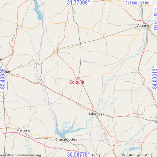
Colquitt GPS coordinates[2]
31° 10' 16.644" North, 84° 43' 59.7" West
| Map corner | latitude | longitude |
|---|---|---|
| Upper-left | 31.77098°, | -85.43638° |
| Center: | 31.17129°, | -84.73325° |
| Lower-right: | 30.56778°, | -84.03013° |
| Map W x H: | 133.8×133.8 km | = 83.1×83.1mi |
| max Lat: | 71.29058° ⇑90.4% North |
| Colquitt: | 31.17129° |
| min Lat: | ⇓9.6% South 19.06759° |
| min Long | Colquitt | max Long |
| -171.73463° | -84.73325° | -66.98998° |
| W 56.5%⇐ | ⇒43.5% E |
Elevation
Elevation of Colquitt is 60 m = 197 ft, and this is 234.8 m = 770 ft below average elevation for this country.
| Max E: |
3189 m = 10463 ft | 77.1% |
| Avg. | 294.8 m = 967 ft | |
| Colquitt | 60 m = 197 ft | |
Min E: |
-60 m = -197 ft | 22.9% |
See also: United States elevation on elevation.city.
Geographical zone
Colquitt is located in North temperate zone (between Tropic of Cancer and the Arctic Circle). Distance of this Northern Tropic circle is 860 km =534.4 mi to South.| Distance of | km | miles | from Colquitt |
|---|---|---|---|
| North Pole | 6541.1 | 4064.4 | to North |
| Arctic Circle | 3935.3 | 2445.3 | to North |
| Tropic Cancer | 860 | 534.4 | to South |
| Equator | 3465.9 | 2153.6 | to South |


Nearby cities:
15 places around Colquitt: (largest is in red/bold)
• Arlington
29.9 km =18.6 mi,  1°
1°
• Ashford
47.9 km =29.8 mi,  271°
271°
• Avon
52.6 km =32.7 mi, 272°
• Bainbridge
33.3 km =20.7 mi,  153°
153°
• Blakely
29.8 km =18.5 mi,  320°
320°
• Camilla
50.2 km =31.2 mi,  82°
82°
• Columbia
38.5 km =23.9 mi,  290°
290°
• Donalsonville
20.1 km =12.5 mi,  223°
223°
• Edison
43 km =26.7 mi,  359°
359°
• Greenwood
52.8 km =32.8 mi,  230°
230°
• Leary
40.7 km =25.3 mi,  30°
30°
• Malone
47.3 km =29.4 mi,  239°
239°
• Morgan
42.7 km =26.5 mi,  17°
17°
• Newton
40.9 km =25.4 mi,  67°
67°
• Webb
52.3 km =32.5 mi,  280°
280°
Sources, notices
• [Note1] Compared only with cities in United States existing in our database
• [Src1] Map data: © OpenStreetMap contributors (CC-BY-SA)
• [Src2] Other city data from geonames.org with taken over terms of usage.
• [Src3] Geographical zone / Annual Mean Temperature by Robert A. Rohde @ Wikipedia
