Eatonton geodata
Eatonton (Georgia) is a seat of a second-order administrative division; located in United States in America/New_York (GMT-4) time zone. With population of 6,520 people, there are 6099 cities with bigger population in this country. Compared to other cities in United States, 83.9% of cities are located further ↑North; 60.9% of cities are located further ←West and 56.2% of cities have higher elevation than Eatonton. Note1


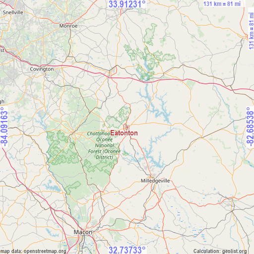
Eatonton GPS coordinates[2]
33° 19' 36.48" North, 83° 23' 18.6" West
| Map corner | latitude | longitude |
|---|---|---|
| Upper-left | 33.91231°, | -84.09163° |
| Center: | 33.3268°, | -83.3885° |
| Lower-right: | 32.73733°, | -82.68538° |
| Map W x H: | 130.6×130.6 km | = 81.2×81.2mi |
| max Lat: | 71.29058° ⇑83.9% North |
| Eatonton: | 33.3268° |
| min Lat: | ⇓16.1% South 19.06759° |
| min Long | Eatonton | max Long |
| -171.73463° | -83.3885° | -66.98998° |
| W 60.9%⇐ | ⇒39.1% E |
Elevation
Elevation of Eatonton is 175 m = 574 ft, and this is 119.8 m = 393 ft below average elevation for this country.
| Max E: |
3189 m = 10463 ft | 56.2% |
| Avg. | 294.8 m = 967 ft | |
| Eatonton | 175 m = 574 ft | |
Min E: |
-60 m = -197 ft | 43.8% |
See also: United States elevation on elevation.city.
Geographical zone
Eatonton is located in North temperate zone (between Tropic of Cancer and the Arctic Circle). Distance of this Northern Tropic circle is 1099.7 km =683.3 mi to South.| Distance of | km | miles | from Eatonton |
|---|---|---|---|
| North Pole | 6301.5 | 3915.6 | to North |
| Arctic Circle | 3695.6 | 2296.3 | to North |
| Tropic Cancer | 1099.7 | 683.3 | to South |
| Equator | 3705.6 | 2302.6 | to South |


Nearby cities:
15 places around Eatonton: (largest is in red/bold)
• Flovilla
48.1 km =29.9 mi,  260°
260°
• Gray
37.8 km =23.5 mi,  200°
200°
• Greensboro
33.6 km =20.9 mi,  34°
34°
• Hardwick
32.6 km =20.3 mi,  151°
151°
• Ivey
47.5 km =29.5 mi,  168°
168°
• Jefferson
15.4 km =9.6 mi, 27°
• Madison
30.8 km =19.1 mi,  346°
346°
• Milledgeville
31 km =19.3 mi, 152°
• Monticello
27.5 km =17.1 mi, 264°
• Mount Zion
35.6 km =22.1 mi,  83°
83°
• Newborn
35.5 km =22.1 mi,  306°
306°
• Rutledge
39.2 km =24.4 mi,  328°
328°
• Social Circle
47.7 km =29.6 mi,  320°
320°
• Sparta
38.7 km =24 mi,  98°
98°
• Union Point
43.4 km =27 mi,  42°
42°
Sources, notices
• [Note1] Compared only with cities in United States existing in our database
• [Src1] Map data: © OpenStreetMap contributors (CC-BY-SA)
• [Src2] Other city data from geonames.org with taken over terms of usage.
• [Src3] Geographical zone / Annual Mean Temperature by Robert A. Rohde @ Wikipedia
