Gray geodata
Gray (Georgia) is a seat of a second-order administrative division; located in United States in America/New_York (GMT-4) time zone. With population of 3,269 people, there are 9198 cities with bigger population in this country. Compared to other cities in United States, 85.1% of cities are located further ↑North; 60.5% of cities are located further ←West and 52.8% of cities have higher elevation than Gray. Note1


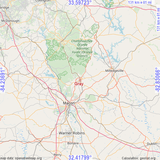
Gray GPS coordinates[2]
33° 0' 34.488" North, 83° 32' 1.608" West
| Map corner | latitude | longitude |
|---|---|---|
| Upper-left | 33.59723°, | -84.23691° |
| Center: | 33.00958°, | -83.53378° |
| Lower-right: | 32.41799°, | -82.83066° |
| Map W x H: | 131.1×131.1 km | = 81.5×81.5mi |
| max Lat: | 71.29058° ⇑85.1% North |
| Gray: | 33.00958° |
| min Lat: | ⇓14.9% South 19.06759° |
| min Long | Gray | max Long |
| -171.73463° | -83.53378° | -66.98998° |
| W 60.5%⇐ | ⇒39.5% E |
Elevation
Elevation of Gray is 188 m = 617 ft, and this is 106.8 m = 350 ft below average elevation for this country.
| Max E: |
3189 m = 10463 ft | 52.8% |
| Avg. | 294.8 m = 967 ft | |
| Gray | 188 m = 617 ft | |
Min E: |
-60 m = -197 ft | 47.2% |
See also: United States elevation on elevation.city.
Geographical zone
Gray is located in North temperate zone (between Tropic of Cancer and the Arctic Circle). Distance of this Northern Tropic circle is 1064.4 km =661.4 mi to South.| Distance of | km | miles | from Gray |
|---|---|---|---|
| North Pole | 6336.7 | 3937.4 | to North |
| Arctic Circle | 3730.9 | 2318.3 | to North |
| Tropic Cancer | 1064.4 | 661.4 | to South |
| Equator | 3670.3 | 2280.6 | to South |


Nearby cities:
15 places around Gray: (largest is in red/bold)
• Eatonton
37.8 km =23.5 mi,  20°
20°
• Flovilla
43.5 km =27 mi,  308°
308°
• Forsyth
37.8 km =23.5 mi,  274°
274°
• Gordon
23.5 km =14.6 mi,  127°
127°
• Hardwick
29.6 km =18.4 mi,  77°
77°
• Indian Springs
44.4 km =27.6 mi, 305°
• Irwinton
40.3 km =25 mi,  123°
123°
• Ivey
25.4 km =15.8 mi, 116°
• Jeffersonville
39.8 km =24.7 mi,  153°
153°
• Macon
20.9 km =13 mi,  206°
206°
• McIntyre
36.8 km =22.9 mi, 119°
• Milledgeville
29.2 km =18.1 mi,  74°
74°
• Monticello
35.7 km =22.2 mi,  337°
337°
• Warner Robins
44.6 km =27.7 mi,  191°
191°
• West Point
35.1 km =21.8 mi,  226°
226°
Sources, notices
• [Note1] Compared only with cities in United States existing in our database
• [Src1] Map data: © OpenStreetMap contributors (CC-BY-SA)
• [Src2] Other city data from geonames.org with taken over terms of usage.
• [Src3] Geographical zone / Annual Mean Temperature by Robert A. Rohde @ Wikipedia
