Milledgeville geodata
Milledgeville (Georgia) is a seat of a second-order administrative division; located in United States in America/New_York (GMT-4) time zone. With population of 18,931 people, there are 2667 cities with bigger population in this country. Compared to other cities in United States, 84.8% of cities are located further ↑North; 61.3% of cities are located further ←West and 68.5% of cities have higher elevation than Milledgeville. Note1


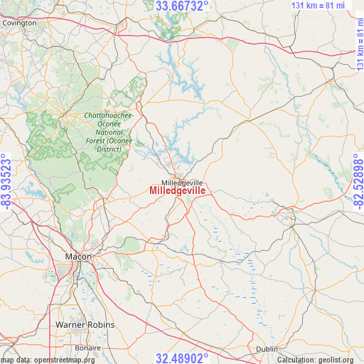
Milledgeville GPS coordinates[2]
33° 4' 48.504" North, 83° 13' 55.56" West
| Map corner | latitude | longitude |
|---|---|---|
| Upper-left | 33.66732°, | -83.93523° |
| Center: | 33.08014°, | -83.2321° |
| Lower-right: | 32.48902°, | -82.52898° |
| Map W x H: | 131×131 km | = 81.4×81.4mi |
| max Lat: | 71.29058° ⇑84.8% North |
| Milledgeville: | 33.08014° |
| min Lat: | ⇓15.2% South 19.06759° |
| min Long | Milledgeville | max Long |
| -171.73463° | -83.2321° | -66.98998° |
| W 61.3%⇐ | ⇒38.7% E |
Elevation
Elevation of Milledgeville is 110 m = 361 ft, and this is 184.8 m = 606 ft below average elevation for this country.
| Max E: |
3189 m = 10463 ft | 68.5% |
| Avg. | 294.8 m = 967 ft | |
| Milledgeville | 110 m = 361 ft | |
Min E: |
-60 m = -197 ft | 31.5% |
See also: United States elevation on elevation.city.
Geographical zone
Milledgeville is located in North temperate zone (between Tropic of Cancer and the Arctic Circle). Distance of this Northern Tropic circle is 1072.2 km =666.2 mi to South.| Distance of | km | miles | from Milledgeville |
|---|---|---|---|
| North Pole | 6328.9 | 3932.6 | to North |
| Arctic Circle | 3723 | 2313.4 | to North |
| Tropic Cancer | 1072.2 | 666.2 | to South |
| Equator | 3678.2 | 2285.5 | to South |


Nearby cities:
15 places around Milledgeville: (largest is in red/bold)
• Eatonton
31 km =19.3 mi,  332°
332°
• Gordon
23.9 km =14.9 mi,  203°
203°
• Gray
29.2 km =18.1 mi,  254°
254°
• Hardwick
1.6 km =1 mi,  148°
148°
• Irwinton
30.4 km =18.9 mi,  169°
169°
• Ivey
20 km =12.4 mi, 195°
• Jefferson
41.7 km =25.9 mi,  349°
349°
• Jeffersonville
44.9 km =27.9 mi,  193°
193°
• Macon
45.9 km =28.5 mi,  234°
234°
• McIntyre
26.3 km =16.3 mi, 171°
• Mount Zion
37.6 km =23.4 mi,  33°
33°
• Sandersville
40.8 km =25.4 mi,  105°
105°
• Sparks
46.1 km =28.6 mi,  88°
88°
• Sparta
32.2 km =20 mi,  47°
47°
• Tennille
42.4 km =26.3 mi, 112°
Sources, notices
• [Note1] Compared only with cities in United States existing in our database
• [Src1] Map data: © OpenStreetMap contributors (CC-BY-SA)
• [Src2] Other city data from geonames.org with taken over terms of usage.
• [Src3] Geographical zone / Annual Mean Temperature by Robert A. Rohde @ Wikipedia
