Zebulon geodata
Zebulon (Georgia) is a seat of a second-order administrative division; located in United States in America/New_York (GMT-4) time zone. With population of 1,153 people, there are 15369 cities with bigger population in this country. Compared to other cities in United States, 84.8% of cities are located further ↑North; 58.1% of cities are located further ←West and 66.1% of cities have lower elevation than Zebulon. Note1


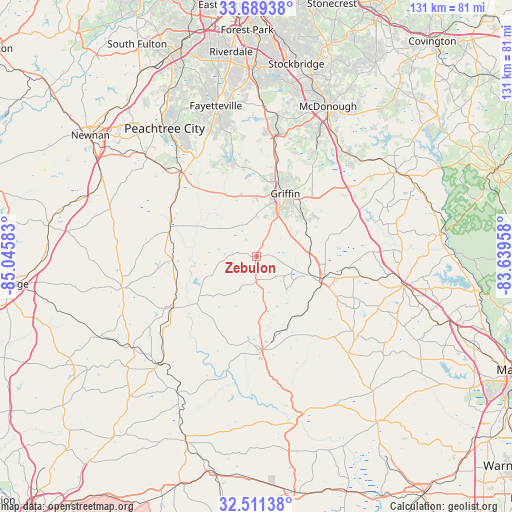
Zebulon GPS coordinates[2]
33° 6' 8.46" North, 84° 20' 33.72" West
| Map corner | latitude | longitude |
|---|---|---|
| Upper-left | 33.68938°, | -85.04583° |
| Center: | 33.10235°, | -84.3427° |
| Lower-right: | 32.51138°, | -83.63958° |
| Map W x H: | 131×131 km | = 81.4×81.4mi |
| max Lat: | 71.29058° ⇑84.8% North |
| Zebulon: | 33.10235° |
| min Lat: | ⇓15.2% South 19.06759° |
| min Long | Zebulon | max Long |
| -171.73463° | -84.3427° | -66.98998° |
| W 58.1%⇐ | ⇒41.9% E |
Elevation
Elevation of Zebulon is 267 m = 876 ft, and this is 27.8 m = 91 ft below average elevation for this country.
| Max E: |
3189 m = 10463 ft | 33.9% |
| Avg. | 294.8 m = 967 ft | |
| Zebulon | 267 m = 876 ft | |
Min E: |
-60 m = -197 ft | 66.1% |
See also: United States elevation on elevation.city.
Geographical zone
Zebulon is located in North temperate zone (between Tropic of Cancer and the Arctic Circle). Distance of this Northern Tropic circle is 1074.7 km =667.8 mi to South.| Distance of | km | miles | from Zebulon |
|---|---|---|---|
| North Pole | 6326.4 | 3931 | to North |
| Arctic Circle | 3720.5 | 2311.8 | to North |
| Tropic Cancer | 1074.7 | 667.8 | to South |
| Equator | 3680.6 | 2287 | to South |


Nearby cities:
15 places around Zebulon: (largest is in red/bold)
• Barnesville
18.2 km =11.3 mi,  106°
106°
• Brooks
23.6 km =14.7 mi,  332°
332°
• East Griffin
19 km =11.8 mi,  33°
33°
• Experiment
19 km =11.8 mi,  17°
17°
• Greenville
35.5 km =22.1 mi,  256°
256°
• Griffin
17.6 km =10.9 mi, 24°
• Hampton
32.1 km =19.9 mi,  9°
9°
• Hannahs Mill
18.9 km =11.7 mi,  181°
181°
• Lincoln Park
26.1 km =16.2 mi, 177°
• Locust Grove
34.7 km =21.6 mi,  38°
38°
• Milner
13.7 km =8.5 mi,  83°
83°
• Senoia
29.7 km =18.5 mi,  318°
318°
• Sunset Village
23.4 km =14.5 mi,  194°
194°
• Thomaston
23.9 km =14.9 mi, 176°
• Woodbury
26 km =16.2 mi,  239°
239°
Sources, notices
• [Note1] Compared only with cities in United States existing in our database
• [Src1] Map data: © OpenStreetMap contributors (CC-BY-SA)
• [Src2] Other city data from geonames.org with taken over terms of usage.
• [Src3] Geographical zone / Annual Mean Temperature by Robert A. Rohde @ Wikipedia
