Hazlehurst geodata
Hazlehurst (Georgia) is a seat of a second-order administrative division; located in United States in America/New_York (GMT-4) time zone. With population of 4,196 people, there are 7989 cities with bigger population in this country. Compared to other cities in United States, 88.9% of cities are located further ↑North; 63.4% of cities are located further ←West and 73.5% of cities have higher elevation than Hazlehurst. Note1


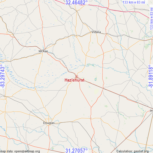
Hazlehurst GPS coordinates[2]
31° 52' 10.668" North, 82° 35' 39.48" West
| Map corner | latitude | longitude |
|---|---|---|
| Upper-left | 32.46482°, | -83.29743° |
| Center: | 31.86963°, | -82.5943° |
| Lower-right: | 31.27057°, | -81.89118° |
| Map W x H: | 132.8×132.8 km | = 82.5×82.5mi |
| max Lat: | 71.29058° ⇑88.9% North |
| Hazlehurst: | 31.86963° |
| min Lat: | ⇓11.1% South 19.06759° |
| min Long | Hazlehurst | max Long |
| -171.73463° | -82.5943° | -66.98998° |
| W 63.4%⇐ | ⇒36.6% E |
Elevation
Elevation of Hazlehurst is 80 m = 262 ft, and this is 214.8 m = 705 ft below average elevation for this country.
| Max E: |
3189 m = 10463 ft | 73.5% |
| Avg. | 294.8 m = 967 ft | |
| Hazlehurst | 80 m = 262 ft | |
Min E: |
-60 m = -197 ft | 26.5% |
See also: United States elevation on elevation.city.
Geographical zone
Hazlehurst is located in North temperate zone (between Tropic of Cancer and the Arctic Circle). Distance of this Northern Tropic circle is 937.7 km =582.7 mi to South.| Distance of | km | miles | from Hazlehurst |
|---|---|---|---|
| North Pole | 6463.5 | 4016.2 | to North |
| Arctic Circle | 3857.6 | 2397 | to North |
| Tropic Cancer | 937.7 | 582.7 | to South |
| Equator | 3543.6 | 2201.9 | to South |


Nearby cities:
15 places around Hazlehurst: (largest is in red/bold)
• Ailey
35.4 km =22 mi,  4°
4°
• Alamo
35.4 km =22 mi,  330°
330°
• Alma
38.8 km =24.1 mi,  161°
161°
• Baxley
25.4 km =15.8 mi,  113°
113°
• Broxton
38.8 km =24.1 mi,  225°
225°
• Douglas
46.8 km =29.1 mi,  211°
211°
• Glenwood
35.2 km =21.9 mi,  348°
348°
• Helena
37.8 km =23.5 mi,  306°
306°
• Lumber City
10.4 km =6.5 mi, 309°
• Lyons
45.2 km =28.1 mi,  34°
34°
• McRae
36.4 km =22.6 mi, 307°
• Mount Vernon
34.3 km =21.3 mi,  359°
359°
• Nicholls
39.3 km =24.4 mi,  185°
185°
• Uvalda
20.2 km =12.6 mi,  23°
23°
• Vidalia
42.3 km =26.3 mi, 23°
Sources, notices
• [Note1] Compared only with cities in United States existing in our database
• [Src1] Map data: © OpenStreetMap contributors (CC-BY-SA)
• [Src2] Other city data from geonames.org with taken over terms of usage.
• [Src3] Geographical zone / Annual Mean Temperature by Robert A. Rohde @ Wikipedia
