Alma geodata
Alma (Georgia) is a seat of a second-order administrative division; located in United States in America/New_York (GMT-4) time zone. With population of 3,536 people, there are 8819 cities with bigger population in this country. Compared to other cities in United States, 89.6% of cities are located further ↑North; 64% of cities are located further ←West and 76.7% of cities have higher elevation than Alma. Note1


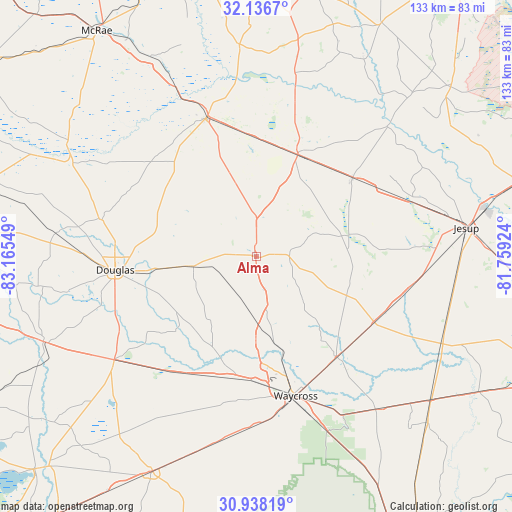
Alma GPS coordinates[2]
31° 32' 21.732" North, 82° 27' 44.496" West
| Map corner | latitude | longitude |
|---|---|---|
| Upper-left | 32.1367°, | -83.16549° |
| Center: | 31.53937°, | -82.46236° |
| Lower-right: | 30.93819°, | -81.75924° |
| Map W x H: | 133.3×133.3 km | = 82.8×82.8mi |
| max Lat: | 71.29058° ⇑89.6% North |
| Alma: | 31.53937° |
| min Lat: | ⇓10.4% South 19.06759° |
| min Long | Alma | max Long |
| -171.73463° | -82.46236° | -66.98998° |
| W 64%⇐ | ⇒36% E |
Elevation
Elevation of Alma is 62 m = 203 ft, and this is 232.8 m = 764 ft below average elevation for this country.
| Max E: |
3189 m = 10463 ft | 76.7% |
| Avg. | 294.8 m = 967 ft | |
| Alma | 62 m = 203 ft | |
Min E: |
-60 m = -197 ft | 23.3% |
See also: United States elevation on elevation.city.
Geographical zone
Alma is located in North temperate zone (between Tropic of Cancer and the Arctic Circle). Distance of this Northern Tropic circle is 900.9 km =559.8 mi to South.| Distance of | km | miles | from Alma |
|---|---|---|---|
| North Pole | 6500.2 | 4039 | to North |
| Arctic Circle | 3894.3 | 2419.8 | to North |
| Tropic Cancer | 900.9 | 559.8 | to South |
| Equator | 3506.8 | 2179 | to South |


Nearby cities:
15 places around Alma: (largest is in red/bold)
• Baxley
28.7 km =17.8 mi,  22°
22°
• Blackshear
33.3 km =20.7 mi,  141°
141°
• Broxton
41.3 km =25.7 mi,  283°
283°
• Deenwood
36 km =22.4 mi,  168°
168°
• Douglas
36.9 km =22.9 mi,  264°
264°
• Hazlehurst
38.8 km =24.1 mi,  341°
341°
• Lumber City
48 km =29.8 mi,  334°
334°
• Nicholls
16.5 km =10.3 mi, 261°
• Odum
43.5 km =27 mi,  71°
71°
• Patterson
34.9 km =21.7 mi,  118°
118°
• Pearson
45.7 km =28.4 mi,  234°
234°
• Screven
42.6 km =26.5 mi,  97°
97°
• Sunnyside
35.3 km =21.9 mi,  161°
161°
• Talmo
27.1 km =16.8 mi,  201°
201°
• Waycross
37.6 km =23.4 mi, 164°
Sources, notices
• [Note1] Compared only with cities in United States existing in our database
• [Src1] Map data: © OpenStreetMap contributors (CC-BY-SA)
• [Src2] Other city data from geonames.org with taken over terms of usage.
• [Src3] Geographical zone / Annual Mean Temperature by Robert A. Rohde @ Wikipedia
