Broxton geodata
Broxton (Georgia) is a populated place; located in United States in America/New_York (GMT-4) time zone. With population of 1,190 people, there are 15180 cities with bigger population in this country. Compared to other cities in United States, 89.4% of cities are located further ↑North; 62.3% of cities are located further ←West and 72% of cities have higher elevation than Broxton. Note1


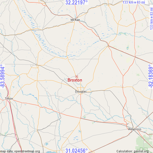
Broxton GPS coordinates[2]
31° 37' 30.684" North, 82° 53' 12.516" West
| Map corner | latitude | longitude |
|---|---|---|
| Upper-left | 32.22197°, | -83.58994° |
| Center: | 31.62519°, | -82.88681° |
| Lower-right: | 31.02456°, | -82.18369° |
| Map W x H: | 133.1×133.1 km | = 82.7×82.7mi |
| max Lat: | 71.29058° ⇑89.4% North |
| Broxton: | 31.62519° |
| min Lat: | ⇓10.6% South 19.06759° |
| min Long | Broxton | max Long |
| -171.73463° | -82.88681° | -66.98998° |
| W 62.3%⇐ | ⇒37.7% E |
Elevation
Elevation of Broxton is 89 m = 292 ft, and this is 205.8 m = 675 ft below average elevation for this country.
| Max E: |
3189 m = 10463 ft | 72% |
| Avg. | 294.8 m = 967 ft | |
| Broxton | 89 m = 292 ft | |
Min E: |
-60 m = -197 ft | 28% |
See also: United States elevation on elevation.city.
Geographical zone
Broxton is located in North temperate zone (between Tropic of Cancer and the Arctic Circle). Distance of this Northern Tropic circle is 910.5 km =565.8 mi to South.| Distance of | km | miles | from Broxton |
|---|---|---|---|
| North Pole | 6490.7 | 4033.1 | to North |
| Arctic Circle | 3884.8 | 2413.9 | to North |
| Tropic Cancer | 910.5 | 565.8 | to South |
| Equator | 3516.4 | 2185 | to South |


Nearby cities:
15 places around Broxton: (largest is in red/bold)
• Alapaha
41.6 km =25.8 mi,  230°
230°
• Alma
41.3 km =25.7 mi,  103°
103°
• Douglas
13.4 km =8.3 mi,  164°
164°
• Enigma
48.1 km =29.9 mi,  240°
240°
• Fitzgerald
36 km =22.4 mi,  286°
286°
• Hazlehurst
38.8 km =24.1 mi,  45°
45°
• Helena
49.9 km =31 mi,  356°
356°
• Lumber City
39.1 km =24.3 mi,  30°
30°
• McRae
49.2 km =30.6 mi, 358°
• Milan
46.7 km =29 mi,  339°
339°
• Nicholls
26.7 km =16.6 mi,  116°
116°
• Ocilla
34.7 km =21.6 mi,  264°
264°
• Pearson
36.6 km =22.7 mi,  174°
174°
• Talmo
45.9 km =28.5 mi,  139°
139°
• Willacoochee
35 km =21.7 mi,  205°
205°
Sources, notices
• [Note1] Compared only with cities in United States existing in our database
• [Src1] Map data: © OpenStreetMap contributors (CC-BY-SA)
• [Src2] Other city data from geonames.org with taken over terms of usage.
• [Src3] Geographical zone / Annual Mean Temperature by Robert A. Rohde @ Wikipedia
