Marietta geodata
Marietta (Georgia) is a seat of a second-order administrative division; located in United States in America/New_York (GMT-4) time zone. With population of 59,067 people, there are 764 cities with bigger population in this country. Compared to other cities in United States, 80.6% of cities are located further ↑North; 57.2% of cities are located further ←West and 78.8% of cities have lower elevation than Marietta. Note1


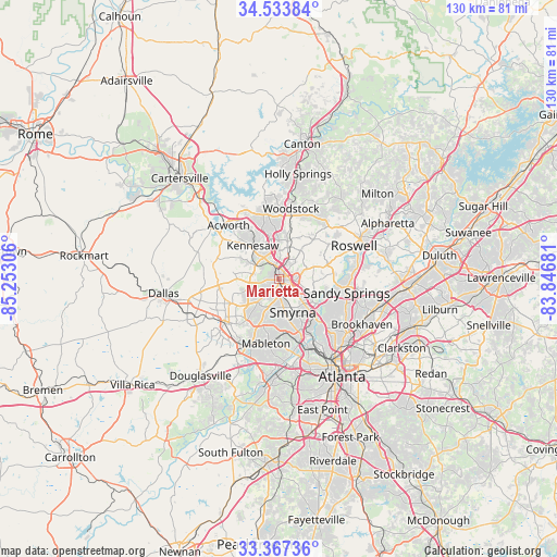
Marietta GPS coordinates[2]
33° 57' 9.36" North, 84° 32' 59.748" West
| Map corner | latitude | longitude |
|---|---|---|
| Upper-left | 34.53384°, | -85.25306° |
| Center: | 33.9526°, | -84.54993° |
| Lower-right: | 33.36736°, | -83.84681° |
| Map W x H: | 129.7×129.7 km | = 80.6×80.6mi |
| max Lat: | 71.29058° ⇑80.6% North |
| Marietta: | 33.9526° |
| min Lat: | ⇓19.4% South 19.06759° |
| min Long | Marietta | max Long |
| -171.73463° | -84.54993° | -66.98998° |
| W 57.2%⇐ | ⇒42.8% E |
Elevation
Elevation of Marietta is 343 m = 1125 ft, and this is 48.2 m = 158 ft above average elevation for this country.
| Max E: |
3189 m = 10463 ft | 21.2% |
| Marietta | 343 m 1125 ft | |
| Avg. | 294.8 m = 967 ft | |
Min E: |
-60 m = -197 ft | 78.8% |
See also: Marietta elevation on elevation.city.
Geographical zone
Marietta is located in North temperate zone (between Tropic of Cancer and the Arctic Circle). Distance of this Northern Tropic circle is 1169.3 km =726.6 mi to South.| Distance of | km | miles | from Marietta |
|---|---|---|---|
| North Pole | 6231.9 | 3872.3 | to North |
| Arctic Circle | 3626 | 2253.1 | to North |
| Tropic Cancer | 1169.3 | 726.6 | to South |
| Equator | 3775.2 | 2345.8 | to South |


Nearby cities:
15 places around Marietta: (largest is in red/bold)
• Acworth
17.3 km =10.7 mi,  316°
316°
• Austell
17.4 km =10.8 mi,  206°
206°
• Dunwoody
19.9 km =12.4 mi,  92°
92°
• Fair Oaks
4 km =2.5 mi,  173°
173°
• Hiram
21.4 km =13.3 mi,  246°
246°
• Kennesaw
9.9 km =6.2 mi, 322°
• Lithia Springs
20.4 km =12.7 mi, 210°
• Mableton
15.2 km =9.4 mi,  191°
191°
• Mountain Park
19.2 km =11.9 mi,  41°
41°
• Powder Springs
16.1 km =10 mi,  230°
230°
• Roswell
19.1 km =11.9 mi,  65°
65°
• Sandy Springs
16.1 km =10 mi,  101°
101°
• Smyrna
8.3 km =5.2 mi,  156°
156°
• Vinings
12.6 km =7.8 mi,  141°
141°
• Woodstock
16.8 km =10.4 mi,  9°
9°
Sources, notices
• [Note1] Compared only with cities in United States existing in our database
• [Src1] Map data: © OpenStreetMap contributors (CC-BY-SA)
• [Src2] Other city data from geonames.org with taken over terms of usage.
• [Src3] Geographical zone / Annual Mean Temperature by Robert A. Rohde @ Wikipedia
