Mableton geodata
Mableton (Georgia) is a populated place; located in United States in America/New_York (GMT-4) time zone. With population of 37,115 people, there are 1313 cities with bigger population in this country. Compared to other cities in United States, 81.4% of cities are located further ↑North; 57.1% of cities are located further ←West and 72.8% of cities have lower elevation than Mableton. Note1


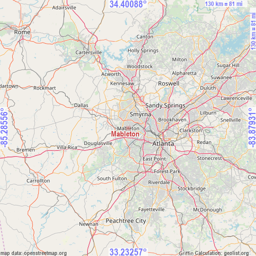
Mableton GPS coordinates[2]
33° 49' 7.392" North, 84° 34' 56.748" West
| Map corner | latitude | longitude |
|---|---|---|
| Upper-left | 34.40088°, | -85.28556° |
| Center: | 33.81872°, | -84.58243° |
| Lower-right: | 33.23257°, | -83.87931° |
| Map W x H: | 129.9×129.9 km | = 80.7×80.7mi |
| max Lat: | 71.29058° ⇑81.4% North |
| Mableton: | 33.81872° |
| min Lat: | ⇓18.6% South 19.06759° |
| min Long | Mableton | max Long |
| -171.73463° | -84.58243° | -66.98998° |
| W 57.1%⇐ | ⇒42.9% E |
Elevation
Elevation of Mableton is 300 m = 984 ft, and this is 5.2 m = 17 ft above average elevation for this country.
| Max E: |
3189 m = 10463 ft | 27.2% |
| Mableton | 300 m 984 ft | |
| Avg. | 294.8 m = 967 ft | |
Min E: |
-60 m = -197 ft | 72.8% |
See also: United States elevation on elevation.city.
Geographical zone
Mableton is located in North temperate zone (between Tropic of Cancer and the Arctic Circle). Distance of this Northern Tropic circle is 1154.4 km =717.3 mi to South.| Distance of | km | miles | from Mableton |
|---|---|---|---|
| North Pole | 6246.8 | 3881.6 | to North |
| Arctic Circle | 3640.9 | 2262.3 | to North |
| Tropic Cancer | 1154.4 | 717.3 | to South |
| Equator | 3760.3 | 2336.5 | to South |


Nearby cities:
15 places around Mableton: (largest is in red/bold)
• Atlanta
19.6 km =12.2 mi,  113°
113°
• Austell
4.8 km =3 mi,  261°
261°
• Brookhaven
22.8 km =14.2 mi,  78°
78°
• College Park
22.1 km =13.7 mi,  146°
146°
• Douglasville
17 km =10.6 mi,  243°
243°
• East Point
20.4 km =12.7 mi,  139°
139°
• Fair Oaks
11.4 km =7.1 mi,  17°
17°
• Hiram
17.8 km =11.1 mi,  290°
290°
• Kennesaw
23 km =14.3 mi,  352°
352°
• Lithia Springs
7.7 km =4.8 mi,  249°
249°
• Marietta
15.2 km =9.4 mi,  11°
11°
• Powder Springs
10.4 km =6.5 mi,  295°
295°
• Sandy Springs
22.2 km =13.8 mi,  58°
58°
• Smyrna
9.6 km =6 mi,  40°
40°
• Vinings
12 km =7.5 mi, 64°
Sources, notices
• [Note1] Compared only with cities in United States existing in our database
• [Src1] Map data: © OpenStreetMap contributors (CC-BY-SA)
• [Src2] Other city data from geonames.org with taken over terms of usage.
• [Src3] Geographical zone / Annual Mean Temperature by Robert A. Rohde @ Wikipedia
