Smyrna geodata
Smyrna (Georgia) is a populated place; located in United States in America/New_York (GMT-4) time zone. With population of 56,146 people, there are 812 cities with bigger population in this country. Compared to other cities in United States, 81.1% of cities are located further ↑North; 57.4% of cities are located further ←West and 76.8% of cities have lower elevation than Smyrna. Note1


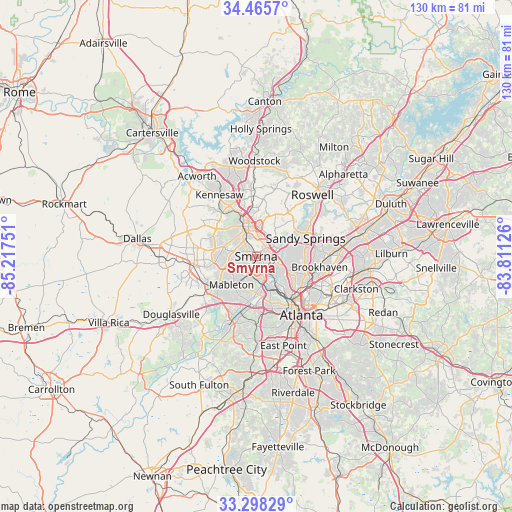
Smyrna GPS coordinates[2]
33° 53' 2.364" North, 84° 30' 51.768" West
| Map corner | latitude | longitude |
|---|---|---|
| Upper-left | 34.4657°, | -85.21751° |
| Center: | 33.88399°, | -84.51438° |
| Lower-right: | 33.29829°, | -83.81126° |
| Map W x H: | 129.8×129.8 km | = 80.7×80.7mi |
| max Lat: | 71.29058° ⇑81.1% North |
| Smyrna: | 33.88399° |
| min Lat: | ⇓18.9% South 19.06759° |
| min Long | Smyrna | max Long |
| -171.73463° | -84.51438° | -66.98998° |
| W 57.4%⇐ | ⇒42.6% E |
Elevation
Elevation of Smyrna is 326 m = 1070 ft, and this is 31.2 m = 102 ft above average elevation for this country.
| Max E: |
3189 m = 10463 ft | 23.2% |
| Smyrna | 326 m 1070 ft | |
| Avg. | 294.8 m = 967 ft | |
Min E: |
-60 m = -197 ft | 76.8% |
See also: Smyrna elevation on elevation.city.
Geographical zone
Smyrna is located in North temperate zone (between Tropic of Cancer and the Arctic Circle). Distance of this Northern Tropic circle is 1161.6 km =721.8 mi to South.| Distance of | km | miles | from Smyrna |
|---|---|---|---|
| North Pole | 6239.5 | 3877 | to North |
| Arctic Circle | 3633.6 | 2257.8 | to North |
| Tropic Cancer | 1161.6 | 721.8 | to South |
| Equator | 3767.5 | 2341 | to South |


Nearby cities:
15 places around Smyrna: (largest is in red/bold)
• Atlanta
19 km =11.8 mi,  142°
142°
• Austell
13.6 km =8.5 mi,  234°
234°
• Brookhaven
16.3 km =10.1 mi,  100°
100°
• Chamblee
19.9 km =12.4 mi,  87°
87°
• Dunwoody
18 km =11.2 mi,  67°
67°
• Fair Oaks
4.6 km =2.9 mi,  322°
322°
• Kennesaw
18.1 km =11.2 mi,  328°
328°
• Lithia Springs
16.8 km =10.4 mi, 233°
• Mableton
9.6 km =6 mi,  220°
220°
• Marietta
8.3 km =5.2 mi,  336°
336°
• North Atlanta
16.5 km =10.3 mi, 97°
• North Druid Hills
20 km =12.4 mi,  111°
111°
• Powder Springs
15.9 km =9.9 mi,  260°
260°
• Sandy Springs
13.3 km =8.3 mi, 70°
• Vinings
5.1 km =3.2 mi, 114°
Sources, notices
• [Note1] Compared only with cities in United States existing in our database
• [Src1] Map data: © OpenStreetMap contributors (CC-BY-SA)
• [Src2] Other city data from geonames.org with taken over terms of usage.
• [Src3] Geographical zone / Annual Mean Temperature by Robert A. Rohde @ Wikipedia
