Ocilla geodata
Ocilla (Georgia) is a seat of a second-order administrative division; located in United States in America/New_York (GMT-4) time zone. With population of 3,387 people, there are 9011 cities with bigger population in this country. Compared to other cities in United States, 89.4% of cities are located further ↑North; 61.3% of cities are located further ←West and 68.6% of cities have higher elevation than Ocilla. Note1


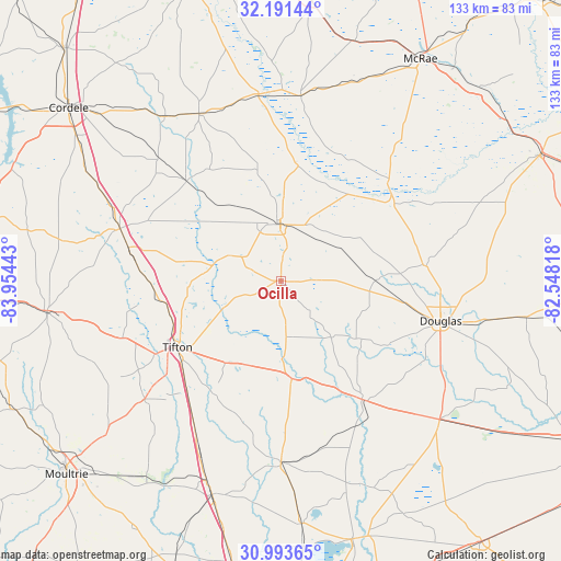
Ocilla GPS coordinates[2]
31° 35' 40.092" North, 83° 15' 4.68" West
| Map corner | latitude | longitude |
|---|---|---|
| Upper-left | 32.19144°, | -83.95443° |
| Center: | 31.59447°, | -83.2513° |
| Lower-right: | 30.99365°, | -82.54818° |
| Map W x H: | 133.2×133.2 km | = 82.8×82.8mi |
| max Lat: | 71.29058° ⇑89.4% North |
| Ocilla: | 31.59447° |
| min Lat: | ⇓10.6% South 19.06759° |
| min Long | Ocilla | max Long |
| -171.73463° | -83.2513° | -66.98998° |
| W 61.3%⇐ | ⇒38.7% E |
Elevation
Elevation of Ocilla is 109 m = 358 ft, and this is 185.8 m = 610 ft below average elevation for this country.
| Max E: |
3189 m = 10463 ft | 68.6% |
| Avg. | 294.8 m = 967 ft | |
| Ocilla | 109 m = 358 ft | |
Min E: |
-60 m = -197 ft | 31.4% |
See also: United States elevation on elevation.city.
Geographical zone
Ocilla is located in North temperate zone (between Tropic of Cancer and the Arctic Circle). Distance of this Northern Tropic circle is 907.1 km =563.6 mi to South.| Distance of | km | miles | from Ocilla |
|---|---|---|---|
| North Pole | 6494.1 | 4035.2 | to North |
| Arctic Circle | 3888.2 | 2416 | to North |
| Tropic Cancer | 907.1 | 563.6 | to South |
| Equator | 3513 | 2182.9 | to South |


Nearby cities:
15 places around Ocilla: (largest is in red/bold)
• Alapaha
23.4 km =14.5 mi,  173°
173°
• Ashburn
40 km =24.9 mi,  288°
288°
• Broxton
34.7 km =21.6 mi,  84°
84°
• Douglas
39.2 km =24.4 mi,  104°
104°
• Enigma
21.5 km =13.4 mi,  200°
200°
• Fitzgerald
13.4 km =8.3 mi,  359°
359°
• Lenox
41.2 km =25.6 mi,  209°
209°
• Nashville
43 km =26.7 mi,  179°
179°
• Omega
43 km =26.7 mi,  229°
229°
• Phillipsburg
30.7 km =19.1 mi,  235°
235°
• Sycamore
37.6 km =23.4 mi,  283°
283°
• Tifton
29.2 km =18.1 mi, 236°
• Ty Ty
39.9 km =24.8 mi,  250°
250°
• Unionville
30.2 km =18.8 mi, 234°
• Willacoochee
34.3 km =21.3 mi,  145°
145°
Sources, notices
• [Note1] Compared only with cities in United States existing in our database
• [Src1] Map data: © OpenStreetMap contributors (CC-BY-SA)
• [Src2] Other city data from geonames.org with taken over terms of usage.
• [Src3] Geographical zone / Annual Mean Temperature by Robert A. Rohde @ Wikipedia
