Willacoochee geodata
Willacoochee (Georgia) is a populated place; located in United States in America/New_York (GMT-4) time zone. With population of 1,393 people, there are 14148 cities with bigger population in this country. Compared to other cities in United States, 90% of cities are located further ↑North; 61.9% of cities are located further ←West and 73.9% of cities have higher elevation than Willacoochee. Note1


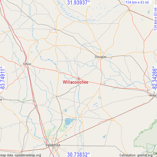
Willacoochee GPS coordinates[2]
31° 20' 26.736" North, 83° 2' 45.528" West
| Map corner | latitude | longitude |
|---|---|---|
| Upper-left | 31.93937°, | -83.74911° |
| Center: | 31.34076°, | -83.04598° |
| Lower-right: | 30.73832°, | -82.34286° |
| Map W x H: | 133.5×133.5 km | = 83×83mi |
| max Lat: | 71.29058° ⇑90% North |
| Willacoochee: | 31.34076° |
| min Lat: | ⇓10% South 19.06759° |
| min Long | Willacoochee | max Long |
| -171.73463° | -83.04598° | -66.98998° |
| W 61.9%⇐ | ⇒38.1% E |
Elevation
Elevation of Willacoochee is 78 m = 256 ft, and this is 216.8 m = 711 ft below average elevation for this country.
| Max E: |
3189 m = 10463 ft | 73.9% |
| Avg. | 294.8 m = 967 ft | |
| Willacoochee | 78 m = 256 ft | |
Min E: |
-60 m = -197 ft | 26.1% |
See also: United States elevation on elevation.city.
Geographical zone
Willacoochee is located in North temperate zone (between Tropic of Cancer and the Arctic Circle). Distance of this Northern Tropic circle is 878.8 km =546.1 mi to South.| Distance of | km | miles | from Willacoochee |
|---|---|---|---|
| North Pole | 6522.3 | 4052.8 | to North |
| Arctic Circle | 3916.4 | 2433.5 | to North |
| Tropic Cancer | 878.8 | 546.1 | to South |
| Equator | 3484.8 | 2165.4 | to South |


Nearby cities:
15 places around Willacoochee: (largest is in red/bold)
• Adel
42.5 km =26.4 mi,  237°
237°
• Alapaha
17.5 km =10.9 mi,  286°
286°
• Broxton
35 km =21.7 mi,  25°
25°
• Douglas
26.4 km =16.4 mi,  44°
44°
• Enigma
28 km =17.4 mi, 286°
• Homerville
44.2 km =27.5 mi,  139°
139°
• Lakeland
33.4 km =20.8 mi,  184°
184°
• Lenox
40.5 km =25.2 mi,  259°
259°
• Moody A F B
43.4 km =27 mi,  201°
201°
• Nashville
24.4 km =15.2 mi,  232°
232°
• Nicholls
43.7 km =27.2 mi,  63°
63°
• Ocilla
34.3 km =21.3 mi,  325°
325°
• Pearson
19 km =11.8 mi,  104°
104°
• Ray City
33 km =20.5 mi,  206°
206°
• Sparks
41.9 km =26 mi, 242°
Sources, notices
• [Note1] Compared only with cities in United States existing in our database
• [Src1] Map data: © OpenStreetMap contributors (CC-BY-SA)
• [Src2] Other city data from geonames.org with taken over terms of usage.
• [Src3] Geographical zone / Annual Mean Temperature by Robert A. Rohde @ Wikipedia
