West Point geodata
West Point (Georgia) is a populated place; located in United States in America/New_York (GMT-4) time zone. With population of 3,238 people, there are 9246 cities with bigger population in this country. Compared to other cities in United States, 86% of cities are located further ↑North; 59.8% of cities are located further ←West and 60.9% of cities have higher elevation than West Point. Note1


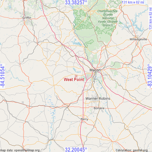
West Point GPS coordinates[2]
32° 47' 36.492" North, 83° 48' 26.676" West
| Map corner | latitude | longitude |
|---|---|---|
| Upper-left | 33.38257°, | -84.51054° |
| Center: | 32.79347°, | -83.80741° |
| Lower-right: | 32.20045°, | -83.10429° |
| Map W x H: | 131.4×131.4 km | = 81.6×81.6mi |
| max Lat: | 71.29058° ⇑86% North |
| West Point: | 32.79347° |
| min Lat: | ⇓14% South 19.06759° |
| min Long | West Point | max Long |
| -171.73463° | -83.80741° | -66.98998° |
| W 59.8%⇐ | ⇒40.2% E |
Elevation
Elevation of West Point is 150 m = 492 ft, and this is 144.8 m = 475 ft below average elevation for this country.
| Max E: |
3189 m = 10463 ft | 60.9% |
| Avg. | 294.8 m = 967 ft | |
| West Point | 150 m = 492 ft | |
Min E: |
-60 m = -197 ft | 39.1% |
See also: United States elevation on elevation.city.
Geographical zone
West Point is located in North temperate zone (between Tropic of Cancer and the Arctic Circle). Distance of this Northern Tropic circle is 1040.4 km =646.5 mi to South.| Distance of | km | miles | from West Point |
|---|---|---|---|
| North Pole | 6360.8 | 3952.4 | to North |
| Arctic Circle | 3754.9 | 2333.2 | to North |
| Tropic Cancer | 1040.4 | 646.5 | to South |
| Equator | 3646.3 | 2265.7 | to South |


Nearby cities:
15 places around West Point: (largest is in red/bold)
• Barnesville
43.6 km =27.1 mi,  311°
311°
• Byron
16.2 km =10.1 mi,  163°
163°
• Centerville
21.2 km =13.2 mi,  148°
148°
• Forsyth
29.4 km =18.3 mi,  335°
335°
• Fort Valley
27.7 km =17.2 mi,  195°
195°
• Gray
35.1 km =21.8 mi,  46°
46°
• Jeffersonville
44.7 km =27.8 mi,  105°
105°
• Knoxville
19.4 km =12.1 mi,  246°
246°
• Macon
17.2 km =10.7 mi,  72°
72°
• Marshallville
39.5 km =24.5 mi, 198°
• Perry
37.9 km =23.5 mi,  169°
169°
• Reynolds
37.5 km =23.3 mi,  226°
226°
• Roberta
20.8 km =12.9 mi, 247°
• Robins Air Force Base
29.2 km =18.1 mi,  134°
134°
• Warner Robins
26 km =16.2 mi,  139°
139°
Sources, notices
• [Note1] Compared only with cities in United States existing in our database
• [Src1] Map data: © OpenStreetMap contributors (CC-BY-SA)
• [Src2] Other city data from geonames.org with taken over terms of usage.
• [Src3] Geographical zone / Annual Mean Temperature by Robert A. Rohde @ Wikipedia
