Knoxville geodata
Knoxville (Georgia) is a seat of a second-order administrative division; located in United States in America/New_York (GMT-4) time zone. With population of 69 people, there are 21049 cities with bigger population in this country. Compared to other cities in United States, 86.3% of cities are located further ↑North; 59.3% of cities are located further ←West and 60.9% of cities have higher elevation than Knoxville. Note1


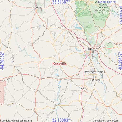
Knoxville GPS coordinates[2]
32° 43' 27.516" North, 83° 59' 51.684" West
| Map corner | latitude | longitude |
|---|---|---|
| Upper-left | 33.31387°, | -84.70082° |
| Center: | 32.72431°, | -83.99769° |
| Lower-right: | 32.13083°, | -83.29457° |
| Map W x H: | 131.5×131.5 km | = 81.7×81.7mi |
| max Lat: | 71.29058° ⇑86.3% North |
| Knoxville: | 32.72431° |
| min Lat: | ⇓13.7% South 19.06759° |
| min Long | Knoxville | max Long |
| -171.73463° | -83.99769° | -66.98998° |
| W 59.3%⇐ | ⇒40.7% E |
Elevation
Elevation of Knoxville is 150 m = 492 ft, and this is 144.8 m = 475 ft below average elevation for this country.
| Max E: |
3189 m = 10463 ft | 60.9% |
| Avg. | 294.8 m = 967 ft | |
| Knoxville | 150 m = 492 ft | |
Min E: |
-60 m = -197 ft | 39.1% |
See also: United States elevation on elevation.city.
Geographical zone
Knoxville is located in North temperate zone (between Tropic of Cancer and the Arctic Circle). Distance of this Northern Tropic circle is 1032.7 km =641.7 mi to South.| Distance of | km | miles | from Knoxville |
|---|---|---|---|
| North Pole | 6368.5 | 3957.2 | to North |
| Arctic Circle | 3762.6 | 2338 | to North |
| Tropic Cancer | 1032.7 | 641.7 | to South |
| Equator | 3638.6 | 2260.9 | to South |


Nearby cities:
15 places around Knoxville: (largest is in red/bold)
• Barnesville
39.6 km =24.6 mi,  338°
338°
• Butler
29.2 km =18.1 mi,  230°
230°
• Byron
23.6 km =14.7 mi,  109°
109°
• Centerville
30.7 km =19.1 mi, 109°
• Forsyth
34.9 km =21.7 mi,  9°
9°
• Fort Valley
21.6 km =13.4 mi,  151°
151°
• Lincoln Park
35 km =21.7 mi,  297°
297°
• Macon
36.5 km =22.7 mi,  69°
69°
• Marshallville
30.3 km =18.8 mi,  169°
169°
• Perry
38.7 km =24 mi,  139°
139°
• Reynolds
20.5 km =12.7 mi,  206°
206°
• Roberta
1.5 km =0.9 mi,  259°
259°
• Thomaston
35.7 km =22.2 mi, 300°
• Warner Robins
36.8 km =22.9 mi, 109°
• West Point
19.4 km =12.1 mi, 66°
Sources, notices
• [Note1] Compared only with cities in United States existing in our database
• [Src1] Map data: © OpenStreetMap contributors (CC-BY-SA)
• [Src2] Other city data from geonames.org with taken over terms of usage.
• [Src3] Geographical zone / Annual Mean Temperature by Robert A. Rohde @ Wikipedia
