Saint Simon Mills geodata
Saint Simon Mills (Georgia) is a populated place; located in United States in America/New_York (GMT-4) time zone. With population of 13,915 people, there are 3458 cities with bigger population in this country. Compared to other cities in United States, 90.4% of cities are located further ↑North; 68.1% of cities are located further ←West and 93.9% of cities have higher elevation than Saint Simon Mills. Note1


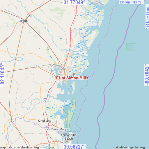
Saint Simon Mills GPS coordinates[2]
31° 10' 14.844" North, 81° 24' 26.352" West
| Map corner | latitude | longitude |
|---|---|---|
| Upper-left | 31.77049°, | -82.11045° |
| Center: | 31.17079°, | -81.40732° |
| Lower-right: | 30.56727°, | -80.7042° |
| Map W x H: | 133.8×133.8 km | = 83.1×83.1mi |
| max Lat: | 71.29058° ⇑90.4% North |
| Saint Simon Mills: | 31.17079° |
| min Lat: | ⇓9.6% South 19.06759° |
| min Long | Saint Simon Mil | max Long |
| -171.73463° | -81.40732° | -66.98998° |
| W 68.1%⇐ | ⇒31.9% E |
Elevation
Elevation of Saint Simon Mills is 10 m = 33 ft, and this is 284.8 m = 934 ft below average elevation for this country.
| Max E: |
3189 m = 10463 ft | 93.9% |
| Avg. | 294.8 m = 967 ft | |
| Saint Simon Mills | 10 m = 33 ft | |
Min E: |
-60 m = -197 ft | 6.1% |
See also: United States elevation on elevation.city.
Geographical zone
Saint Simon Mills is located in North temperate zone (between Tropic of Cancer and the Arctic Circle). Distance of this Northern Tropic circle is 859.9 km =534.3 mi to South.| Distance of | km | miles | from Saint Simon Mills |
|---|---|---|---|
| North Pole | 6541.2 | 4064.5 | to North |
| Arctic Circle | 3935.3 | 2445.3 | to North |
| Tropic Cancer | 859.9 | 534.3 | to South |
| Equator | 3465.9 | 2153.6 | to South |


Nearby cities:
15 places around Saint Simon Mills: (largest is in red/bold)
• Brunswick
8.3 km =5.2 mi,  253°
253°
• Country Club Estates
7.1 km =4.4 mi,  310°
310°
• Darien
22.3 km =13.9 mi,  353°
353°
• Dock Junction
11 km =6.8 mi,  288°
288°
• Fernandina Beach
56 km =34.8 mi,  185°
185°
• Jesup
66.5 km =41.3 mi,  316°
316°
• Kings Bay Base
44.1 km =27.4 mi,  200°
200°
• Kingsland
49.2 km =30.6 mi,  213°
213°
• Nahunta
54.7 km =34 mi,  273°
273°
• Riceboro
62.8 km =39 mi,  357°
357°
• Saint Simons Island
4.2 km =2.6 mi,  122°
122°
• St Marys
48.6 km =30.2 mi, 198°
• St. Marys
50.7 km =31.5 mi, 195°
• Woodbine
37.9 km =23.5 mi,  232°
232°
• Yulee
62.9 km =39.1 mi, 197°
Sources, notices
• [Note1] Compared only with cities in United States existing in our database
• [Src1] Map data: © OpenStreetMap contributors (CC-BY-SA)
• [Src2] Other city data from geonames.org with taken over terms of usage.
• [Src3] Geographical zone / Annual Mean Temperature by Robert A. Rohde @ Wikipedia
