Kingsland geodata
Kingsland (Georgia) is a populated place; located in United States in America/New_York (GMT-4) time zone. With population of 16,487 people, there are 2978 cities with bigger population in this country. Compared to other cities in United States, 91.1% of cities are located further ↑North; 66.7% of cities are located further ←West and 90.5% of cities have higher elevation than Kingsland. Note1


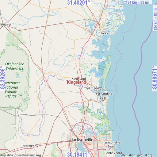
Kingsland GPS coordinates[2]
30° 47' 59.856" North, 81° 41' 23.388" West
| Map corner | latitude | longitude |
|---|---|---|
| Upper-left | 31.40201°, | -82.39296° |
| Center: | 30.79996°, | -81.68983° |
| Lower-right: | 30.19411°, | -80.98671° |
| Map W x H: | 134.3×134.3 km | = 83.5×83.5mi |
| max Lat: | 71.29058° ⇑91.1% North |
| Kingsland: | 30.79996° |
| min Lat: | ⇓8.9% South 19.06759° |
| min Long | Kingsland | max Long |
| -171.73463° | -81.68983° | -66.98998° |
| W 66.7%⇐ | ⇒33.3% E |
Elevation
Elevation of Kingsland is 15 m = 49 ft, and this is 279.8 m = 918 ft below average elevation for this country.
| Max E: |
3189 m = 10463 ft | 90.5% |
| Avg. | 294.8 m = 967 ft | |
| Kingsland | 15 m = 49 ft | |
Min E: |
-60 m = -197 ft | 9.5% |
See also: United States elevation on elevation.city.
Geographical zone
Kingsland is located in North temperate zone (between Tropic of Cancer and the Arctic Circle). Distance of this Northern Tropic circle is 818.7 km =508.7 mi to South.| Distance of | km | miles | from Kingsland |
|---|---|---|---|
| North Pole | 6582.4 | 4090.1 | to North |
| Arctic Circle | 3976.5 | 2470.9 | to North |
| Tropic Cancer | 818.7 | 508.7 | to South |
| Equator | 3424.6 | 2127.9 | to South |


Nearby cities:
15 places around Kingsland: (largest is in red/bold)
• Brunswick
43.3 km =26.9 mi,  25°
25°
• Callahan
29.7 km =18.5 mi,  206°
206°
• Dock Junction
47.7 km =29.6 mi,  20°
20°
• Fernandina Beach
26.1 km =16.2 mi,  123°
123°
• Folkston
30.9 km =19.2 mi,  276°
276°
• Hilliard
24.9 km =15.5 mi,  240°
240°
• Homeland
32.4 km =20.1 mi, 281°
• Kings Bay Base
11.8 km =7.3 mi,  90°
90°
• Nassau Village-Ratliff
34.1 km =21.2 mi,  199°
199°
• Saint Simon Mills
49.2 km =30.6 mi, 33°
• Saint Simons Island
49.5 km =30.8 mi,  38°
38°
• St Marys
12.3 km =7.6 mi,  113°
113°
• St. Marys
15.7 km =9.8 mi, 119°
• Woodbine
18.5 km =11.5 mi,  349°
349°
• Yulee
20.3 km =12.6 mi,  156°
156°
Sources, notices
• [Note1] Compared only with cities in United States existing in our database
• [Src1] Map data: © OpenStreetMap contributors (CC-BY-SA)
• [Src2] Other city data from geonames.org with taken over terms of usage.
• [Src3] Geographical zone / Annual Mean Temperature by Robert A. Rohde @ Wikipedia
