Woodbine geodata
Woodbine (Georgia) is a seat of a second-order administrative division; located in United States in America/New_York (GMT-4) time zone. With population of 1,285 people, there are 14661 cities with bigger population in this country. Compared to other cities in United States, 90.8% of cities are located further ↑North; 66.6% of cities are located further ←West and 92.1% of cities have higher elevation than Woodbine. Note1


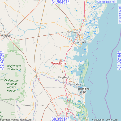
Woodbine GPS coordinates[2]
30° 57' 50.256" North, 81° 43' 26.976" West
| Map corner | latitude | longitude |
|---|---|---|
| Upper-left | 31.56497°, | -82.42729° |
| Center: | 30.96396°, | -81.72416° |
| Lower-right: | 30.35914°, | -81.02104° |
| Map W x H: | 134.1×134.1 km | = 83.3×83.3mi |
| max Lat: | 71.29058° ⇑90.8% North |
| Woodbine: | 30.96396° |
| min Lat: | ⇓9.2% South 19.06759° |
| min Long | Woodbine | max Long |
| -171.73463° | -81.72416° | -66.98998° |
| W 66.6%⇐ | ⇒33.4% E |
Elevation
Elevation of Woodbine is 12 m = 39 ft, and this is 282.8 m = 928 ft below average elevation for this country.
| Max E: |
3189 m = 10463 ft | 92.1% |
| Avg. | 294.8 m = 967 ft | |
| Woodbine | 12 m = 39 ft | |
Min E: |
-60 m = -197 ft | 7.9% |
See also: United States elevation on elevation.city.
Geographical zone
Woodbine is located in North temperate zone (between Tropic of Cancer and the Arctic Circle). Distance of this Northern Tropic circle is 837 km =520.1 mi to South.| Distance of | km | miles | from Woodbine |
|---|---|---|---|
| North Pole | 6564.2 | 4078.8 | to North |
| Arctic Circle | 3958.3 | 2459.6 | to North |
| Tropic Cancer | 837 | 520.1 | to South |
| Equator | 3442.9 | 2139.3 | to South |


Nearby cities:
15 places around Woodbine: (largest is in red/bold)
• Brunswick
30.3 km =18.8 mi,  46°
46°
• Country Club Estates
37.1 km =23.1 mi,  41°
41°
• Dock Junction
33.1 km =20.6 mi, 36°
• Fernandina Beach
41.2 km =25.6 mi,  142°
142°
• Folkston
31.1 km =19.3 mi,  241°
241°
• Hilliard
35.5 km =22.1 mi,  211°
211°
• Homeland
30.9 km =19.2 mi,  247°
247°
• Kings Bay Base
23.8 km =14.8 mi, 140°
• Kingsland
18.5 km =11.5 mi,  169°
169°
• Nahunta
36.2 km =22.5 mi,  317°
317°
• Saint Simon Mills
37.9 km =23.5 mi, 52°
• Saint Simons Island
39.6 km =24.6 mi,  58°
58°
• St Marys
27.2 km =16.9 mi,  147°
147°
• St. Marys
31 km =19.3 mi, 146°
• Yulee
38.6 km =24 mi,  163°
163°
Sources, notices
• [Note1] Compared only with cities in United States existing in our database
• [Src1] Map data: © OpenStreetMap contributors (CC-BY-SA)
• [Src2] Other city data from geonames.org with taken over terms of usage.
• [Src3] Geographical zone / Annual Mean Temperature by Robert A. Rohde @ Wikipedia
