Talbotton geodata
Talbotton (Georgia) is a seat of a second-order administrative division; located in United States in America/New_York (GMT-4) time zone. With population of 887 people, there are 17063 cities with bigger population in this country. Compared to other cities in United States, 86.5% of cities are located further ↑North; 57.3% of cities are located further ←West and 54.4% of cities have lower elevation than Talbotton. Note1


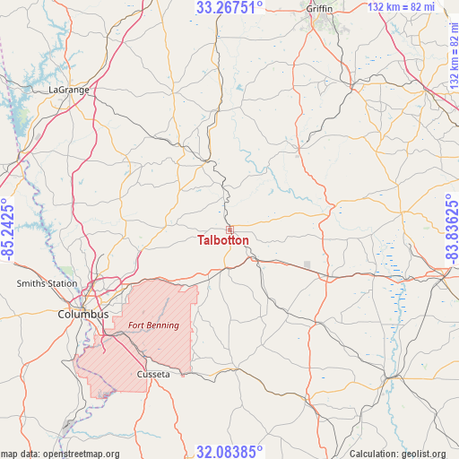
Talbotton GPS coordinates[2]
32° 40' 39.504" North, 84° 32' 21.732" West
| Map corner | latitude | longitude |
|---|---|---|
| Upper-left | 33.26751°, | -85.2425° |
| Center: | 32.67764°, | -84.53937° |
| Lower-right: | 32.08385°, | -83.83625° |
| Map W x H: | 131.6×131.6 km | = 81.8×81.8mi |
| max Lat: | 71.29058° ⇑86.5% North |
| Talbotton: | 32.67764° |
| min Lat: | ⇓13.5% South 19.06759° |
| min Long | Talbotton | max Long |
| -171.73463° | -84.53937° | -66.98998° |
| W 57.3%⇐ | ⇒42.7% E |
Elevation
Elevation of Talbotton is 216 m = 709 ft, and this is 78.8 m = 259 ft below average elevation for this country.
| Max E: |
3189 m = 10463 ft | 45.6% |
| Avg. | 294.8 m = 967 ft | |
| Talbotton | 216 m = 709 ft | |
Min E: |
-60 m = -197 ft | 54.4% |
See also: United States elevation on elevation.city.
Geographical zone
Talbotton is located in North temperate zone (between Tropic of Cancer and the Arctic Circle). Distance of this Northern Tropic circle is 1027.5 km =638.5 mi to South.| Distance of | km | miles | from Talbotton |
|---|---|---|---|
| North Pole | 6373.6 | 3960.4 | to North |
| Arctic Circle | 3767.8 | 2341.2 | to North |
| Tropic Cancer | 1027.5 | 638.5 | to South |
| Equator | 3633.4 | 2257.7 | to South |


Nearby cities:
15 places around Talbotton: (largest is in red/bold)
• Buena Vista
39.9 km =24.8 mi,  177°
177°
• Butler
31.2 km =19.4 mi,  115°
115°
• Cusseta
46.8 km =29.1 mi,  207°
207°
• Greenville
42.3 km =26.3 mi,  337°
337°
• Hamilton
32.6 km =20.3 mi,  285°
285°
• Hannahs Mill
33.5 km =20.8 mi,  32°
32°
• Lincoln Park
28.8 km =17.9 mi,  42°
42°
• Manchester
21.6 km =13.4 mi, 339°
• Pine Mountain
36 km =22.4 mi,  305°
305°
• Reynolds
43.5 km =27 mi,  107°
107°
• Sardis
16.2 km =10.1 mi,  324°
324°
• Sunset Village
27.6 km =17.1 mi, 27°
• Thomaston
30.7 km =19.1 mi, 40°
• Waverly Hall
18.6 km =11.6 mi,  271°
271°
• Woodbury
34.3 km =21.3 mi,  353°
353°
Sources, notices
• [Note1] Compared only with cities in United States existing in our database
• [Src1] Map data: © OpenStreetMap contributors (CC-BY-SA)
• [Src2] Other city data from geonames.org with taken over terms of usage.
• [Src3] Geographical zone / Annual Mean Temperature by Robert A. Rohde @ Wikipedia
