Greenville geodata
Greenville (Georgia) is a seat of a second-order administrative division; located in United States in America/New_York (GMT-4) time zone. With population of 862 people, there are 17264 cities with bigger population in this country. Compared to other cities in United States, 85% of cities are located further ↑North; 56.6% of cities are located further ←West and 66.3% of cities have lower elevation than Greenville. Note1


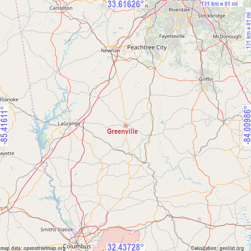
Greenville GPS coordinates[2]
33° 1' 43.464" North, 84° 42' 46.728" West
| Map corner | latitude | longitude |
|---|---|---|
| Upper-left | 33.61626°, | -85.41611° |
| Center: | 33.02874°, | -84.71298° |
| Lower-right: | 32.43728°, | -84.00986° |
| Map W x H: | 131.1×131.1 km | = 81.5×81.5mi |
| max Lat: | 71.29058° ⇑85% North |
| Greenville: | 33.02874° |
| min Lat: | ⇓15% South 19.06759° |
| min Long | Greenville | max Long |
| -171.73463° | -84.71298° | -66.98998° |
| W 56.6%⇐ | ⇒43.4% E |
Elevation
Elevation of Greenville is 268 m = 879 ft, and this is 26.8 m = 88 ft below average elevation for this country.
| Max E: |
3189 m = 10463 ft | 33.7% |
| Avg. | 294.8 m = 967 ft | |
| Greenville | 268 m = 879 ft | |
Min E: |
-60 m = -197 ft | 66.3% |
See also: United States elevation on elevation.city.
Geographical zone
Greenville is located in North temperate zone (between Tropic of Cancer and the Arctic Circle). Distance of this Northern Tropic circle is 1066.5 km =662.7 mi to South.| Distance of | km | miles | from Greenville |
|---|---|---|---|
| North Pole | 6334.6 | 3936.1 | to North |
| Arctic Circle | 3728.7 | 2316.9 | to North |
| Tropic Cancer | 1066.5 | 662.7 | to South |
| Equator | 3672.5 | 2282 | to South |


Nearby cities:
15 places around Greenville: (largest is in red/bold)
• Brooks
37.5 km =23.3 mi,  38°
38°
• East Newnan
36.3 km =22.6 mi,  350°
350°
• Grantville
25.6 km =15.9 mi,  333°
333°
• Hamilton
33.7 km =20.9 mi,  206°
206°
• Hannahs Mill
35.5 km =22.1 mi,  107°
107°
• Hogansville
24.7 km =15.3 mi,  310°
310°
• LaGrange
29.7 km =18.5 mi,  272°
272°
• Luthersville
20.4 km =12.7 mi, 351°
• Manchester
20.7 km =12.9 mi,  155°
155°
• Pine Mountain
22.5 km =14 mi,  215°
215°
• Sardis
26.7 km =16.6 mi, 164°
• Senoia
33.8 km =21 mi,  25°
25°
• Sunset Village
32.3 km =20.1 mi,  116°
116°
• Woodbury
13.1 km =8.1 mi, 112°
• Zebulon
35.5 km =22.1 mi,  76°
76°
Sources, notices
• [Note1] Compared only with cities in United States existing in our database
• [Src1] Map data: © OpenStreetMap contributors (CC-BY-SA)
• [Src2] Other city data from geonames.org with taken over terms of usage.
• [Src3] Geographical zone / Annual Mean Temperature by Robert A. Rohde @ Wikipedia
