Pine Mountain geodata
Pine Mountain (Georgia) is a populated place; located in United States in America/New_York (GMT-4) time zone. With population of 1,358 people, there are 14314 cities with bigger population in this country. Compared to other cities in United States, 85.7% of cities are located further ↑North; 56.2% of cities are located further ←West and 69% of cities have lower elevation than Pine Mountain. Note1


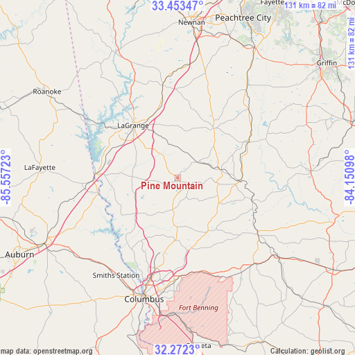
Pine Mountain GPS coordinates[2]
32° 51' 53.46" North, 84° 51' 14.76" West
| Map corner | latitude | longitude |
|---|---|---|
| Upper-left | 33.45347°, | -85.55723° |
| Center: | 32.86485°, | -84.8541° |
| Lower-right: | 32.2723°, | -84.15098° |
| Map W x H: | 131.3×131.3 km | = 81.6×81.6mi |
| max Lat: | 71.29058° ⇑85.7% North |
| Pine Mountain: | 32.86485° |
| min Lat: | ⇓14.3% South 19.06759° |
| min Long | Pine Mountain | max Long |
| -171.73463° | -84.8541° | -66.98998° |
| W 56.2%⇐ | ⇒43.8% E |
Elevation
Elevation of Pine Mountain is 281 m = 922 ft, and this is 13.8 m = 45 ft below average elevation for this country.
| Max E: |
3189 m = 10463 ft | 31% |
| Avg. | 294.8 m = 967 ft | |
| Pine Mountain | 281 m = 922 ft | |
Min E: |
-60 m = -197 ft | 69% |
See also: United States elevation on elevation.city.
Geographical zone
Pine Mountain is located in North temperate zone (between Tropic of Cancer and the Arctic Circle). Distance of this Northern Tropic circle is 1048.3 km =651.4 mi to South.| Distance of | km | miles | from Pine Mountain |
|---|---|---|---|
| North Pole | 6352.8 | 3947.4 | to North |
| Arctic Circle | 3746.9 | 2328.2 | to North |
| Tropic Cancer | 1048.3 | 651.4 | to South |
| Equator | 3654.2 | 2270.6 | to South |


Nearby cities:
15 places around Pine Mountain: (largest is in red/bold)
• Grantville
41.2 km =25.6 mi,  2°
2°
• Greenville
22.5 km =14 mi,  35°
35°
• Hamilton
12 km =7.5 mi,  189°
189°
• Hogansville
34.7 km =21.6 mi,  350°
350°
• Huguley
35.2 km =21.9 mi,  264°
264°
• LaGrange
25.5 km =15.8 mi,  319°
319°
• Lanett
31.4 km =19.5 mi,  270°
270°
• Luthersville
39.7 km =24.7 mi,  14°
14°
• Manchester
21.9 km =13.6 mi,  91°
91°
• Sardis
21.5 km =13.4 mi,  110°
110°
• Talbotton
36 km =22.4 mi,  125°
125°
• Valley
30.8 km =19.1 mi, 260°
• Waverly Hall
22.9 km =14.2 mi,  151°
151°
• West Point
30.8 km =19.1 mi, 272°
• Woodbury
28.6 km =17.8 mi,  62°
62°
Sources, notices
• [Note1] Compared only with cities in United States existing in our database
• [Src1] Map data: © OpenStreetMap contributors (CC-BY-SA)
• [Src2] Other city data from geonames.org with taken over terms of usage.
• [Src3] Geographical zone / Annual Mean Temperature by Robert A. Rohde @ Wikipedia
