Manchester geodata
Manchester (Georgia) is a populated place; located in United States in America/New_York (GMT-4) time zone. With population of 4,095 people, there are 8104 cities with bigger population in this country. Compared to other cities in United States, 85.7% of cities are located further ↑North; 56.9% of cities are located further ←West and 66.3% of cities have lower elevation than Manchester. Note1


Manchester GPS coordinates[2]
32° 51' 35.46" North, 84° 37' 11.748" West
| Map corner | latitude | longitude |
|---|---|---|
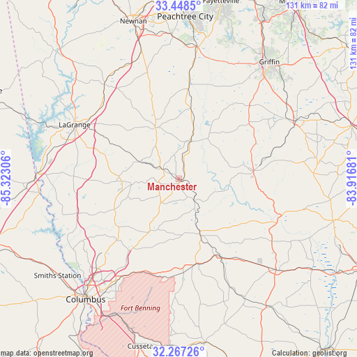
| Upper-left | 33.4485°, | -85.32306° |
| Center: | 32.85985°, | -84.61993° |
| Lower-right: | 32.26726°, | -83.91681° |
| Map W x H: | 131.3×131.3 km | = 81.6×81.6mi |
| max Lat: | 71.29058° ⇑85.7% North |
| Manchester: | 32.85985° |
| min Lat: | ⇓14.3% South 19.06759° |
| min Long | Manchester | max Long |
| -171.73463° | -84.61993° | -66.98998° |
| W 56.9%⇐ | ⇒43.1% E |
Elevation
Elevation of Manchester is 268 m = 879 ft, and this is 26.8 m = 88 ft below average elevation for this country.
| Max E: |
3189 m = 10463 ft | 33.7% |
| Avg. | 294.8 m = 967 ft | |
| Manchester | 268 m = 879 ft | |
Min E: |
-60 m = -197 ft | 66.3% |
See also: United States elevation on elevation.city.
Geographical zone
Manchester is located in North temperate zone (between Tropic of Cancer and the Arctic Circle). Distance of this Northern Tropic circle is 1047.8 km =651.1 mi to South.| Distance of | km | miles | from Manchester |
|---|---|---|---|
| North Pole | 6353.4 | 3947.8 | to North |
| Arctic Circle | 3747.5 | 2328.6 | to North |
| Tropic Cancer | 1047.8 | 651.1 | to South |
| Equator | 3653.7 | 2270.3 | to South |


Nearby cities:
15 places around Manchester: (largest is in red/bold)
• Greenville
20.7 km =12.9 mi,  335°
335°
• Hamilton
26.4 km =16.4 mi,  244°
244°
• Hannahs Mill
26.5 km =16.5 mi,  72°
72°
• Hogansville
44.4 km =27.6 mi,  321°
321°
• LaGrange
43.3 km =26.9 mi,  297°
297°
• Lincoln Park
27 km =16.8 mi,  88°
88°
• Luthersville
40.6 km =25.2 mi, 343°
• Pine Mountain
21.9 km =13.6 mi,  271°
271°
• Sardis
7.3 km =4.5 mi,  194°
194°
• Sunset Village
20.6 km =12.8 mi,  78°
78°
• Talbotton
21.6 km =13.4 mi,  159°
159°
• Thomaston
27.6 km =17.1 mi, 83°
• Waverly Hall
22.5 km =14 mi,  209°
209°
• Woodbury
14.2 km =8.8 mi,  14°
14°
• Zebulon
37.4 km =23.2 mi,  43°
43°
Sources, notices
• [Note1] Compared only with cities in United States existing in our database
• [Src1] Map data: © OpenStreetMap contributors (CC-BY-SA)
• [Src2] Other city data from geonames.org with taken over terms of usage.
• [Src3] Geographical zone / Annual Mean Temperature by Robert A. Rohde @ Wikipedia
