Jackson geodata
Jackson (Missouri) is a seat of a second-order administrative division; located in United States in America/Chicago (GMT-5) time zone. With population of 14,869 people, there are 3267 cities with bigger population in this country. Compared to other cities in United States, 64.5% of cities are located further ↑North; 58.1% of cities are located further →East and 62.4% of cities have higher elevation than Jackson. Note1
Administrative division(s):
- Level 1: Missouri
- Level 2: Cape Girardeau County
- Level 3: Township of Byrd


Jackson GPS coordinates[2]
37° 22' 56.172" North, 89° 39' 58.356" West
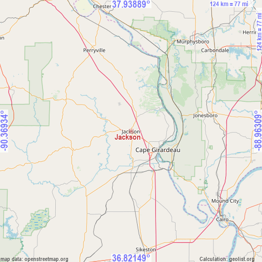
| Map corner | latitude | longitude |
|---|---|---|
| Upper-left | 37.93889°, | -90.36934° |
| Center: | 37.38227°, | -89.66621° |
| Lower-right: | 36.82149°, | -88.96309° |
| Map W x H: | 124.2×124.2 km | = 77.2×77.2mi |
| max Lat: | 71.29058° ⇑64.5% North |
| Jackson: | 37.38227° |
| min Lat: | ⇓35.5% South 19.06759° |
| min Long | Jackson | max Long |
| -171.73463° | -89.66621° | -66.98998° |
| W 41.9%⇐ | ⇒58.1% E |
Elevation
Elevation of Jackson is 142 m = 466 ft, and this is 152.8 m = 501 ft below average elevation for this country.
| Max E: |
3189 m = 10463 ft | 62.4% |
| Avg. | 294.8 m = 967 ft | |
| Jackson | 142 m = 466 ft | |
Min E: |
-60 m = -197 ft | 37.6% |
See also: United States elevation on elevation.city.
Geographical zone
Jackson is located in North temperate zone (between Tropic of Cancer and the Arctic Circle). Distance of this Northern Tropic circle is 1550.6 km =963.5 mi to South.| Distance of | km | miles | from Jackson |
|---|---|---|---|
| North Pole | 5850.5 | 3635.3 | to North |
| Arctic Circle | 3244.7 | 2016.2 | to North |
| Tropic Cancer | 1550.6 | 963.5 | to South |
| Equator | 4156.5 | 2582.7 | to South |


Nearby cities:
15 places around Jackson: (largest is in red/bold)
• Advance
37.6 km =23.4 mi,  214°
214°
• Anna
38 km =23.6 mi,  76°
76°
• Benton
32.9 km =20.4 mi,  163°
163°
• Cape Girardeau
15.6 km =9.7 mi,  122°
122°
• Chaffee
22.5 km =14 mi,  177°
177°
• Cobden
40 km =24.9 mi,  65°
65°
• Grand Tower
30.9 km =19.2 mi,  28°
28°
• Jonesboro
36 km =22.4 mi, 77°
• Kelso
23.7 km =14.7 mi,  154°
154°
• Marble Hill
28.2 km =17.5 mi,  252°
252°
• Morley
38 km =23.6 mi,  172°
172°
• Olive Branch
36.6 km =22.7 mi,  130°
130°
• Oran
33.1 km =20.6 mi, 178°
• Scott City
22.3 km =13.9 mi, 145°
• Tamms
38.7 km =24 mi, 115°
Sources, notices
• [Note1] Compared only with cities in United States existing in our database
• [Src1] Map data: © OpenStreetMap contributors (CC-BY-SA)
• [Src2] Other city data from geonames.org with taken over terms of usage.
• [Src3] Geographical zone / Annual Mean Temperature by Robert A. Rohde @ Wikipedia
