Monticello geodata
Monticello (Illinois) is a seat of a second-order administrative division; located in United States in America/Chicago (GMT-5) time zone. With population of 5,509 people, there are 6757 cities with bigger population in this country. Compared to other cities in United States, 53.8% of cities are located further ↓South; 55% of cities are located further →East and 50.7% of cities have lower elevation than Monticello. Note1


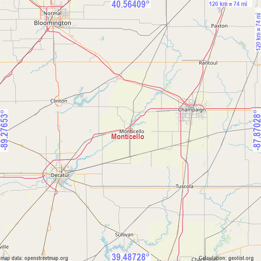
Monticello GPS coordinates[2]
40° 1' 40.116" North, 88° 34' 24.24" West
| Map corner | latitude | longitude |
|---|---|---|
| Upper-left | 40.56409°, | -89.27653° |
| Center: | 40.02781°, | -88.5734° |
| Lower-right: | 39.48728°, | -87.87028° |
| Map W x H: | 119.7×119.7 km | = 74.4×74.4mi |
| max Lat: | 71.29058° ⇑46.2% North |
| Monticello: | 40.02781° |
| min Lat: | ⇓53.8% South 19.06759° |
| min Long | Monticello | max Long |
| -171.73463° | -88.5734° | -66.98998° |
| W 45%⇐ | ⇒55% E |
Elevation
Elevation of Monticello is 201 m = 659 ft, and this is 93.8 m = 308 ft below average elevation for this country.
| Max E: |
3189 m = 10463 ft | 49.3% |
| Avg. | 294.8 m = 967 ft | |
| Monticello | 201 m = 659 ft | |
Min E: |
-60 m = -197 ft | 50.7% |
See also: United States elevation on elevation.city.
Geographical zone
Monticello is located in North temperate zone (between Tropic of Cancer and the Arctic Circle). Distance of this Northern Tropic circle is 1844.8 km =1146.3 mi to South.| Distance of | km | miles | from Monticello |
|---|---|---|---|
| North Pole | 5556.4 | 3452.6 | to North |
| Arctic Circle | 2950.5 | 1833.4 | to North |
| Tropic Cancer | 1844.8 | 1146.3 | to South |
| Equator | 4450.7 | 2765.5 | to South |


Nearby cities:
15 places around Monticello: (largest is in red/bold)
• Argenta
21.8 km =13.5 mi,  256°
256°
• Atwood
27.1 km =16.8 mi,  159°
159°
• Bement
11.8 km =7.3 mi,  179°
179°
• Cerro Gordo
20.2 km =12.6 mi,  220°
220°
• Champaign
29.8 km =18.5 mi,  70°
70°
• Chapin
23.6 km =14.7 mi,  226°
226°
• Farmer City
24.7 km =15.3 mi,  346°
346°
• Lake of the Woods
26.4 km =16.4 mi,  41°
41°
• Mahomet
23.5 km =14.6 mi, 37°
• Mansfield
21.2 km =13.2 mi,  15°
15°
• Oreana
26.8 km =16.7 mi,  248°
248°
• Pesotum
28.5 km =17.7 mi,  116°
116°
• Savoy
27.5 km =17.1 mi,  83°
83°
• Tolono
27.2 km =16.9 mi,  99°
99°
• Urbana
32.5 km =20.2 mi, 73°
Sources, notices
• [Note1] Compared only with cities in United States existing in our database
• [Src1] Map data: © OpenStreetMap contributors (CC-BY-SA)
• [Src2] Other city data from geonames.org with taken over terms of usage.
• [Src3] Geographical zone / Annual Mean Temperature by Robert A. Rohde @ Wikipedia
