Galena geodata
Galena (Indiana) is a populated place; located in United States in America/Kentucky/Louisville (GMT-4) time zone. With population of 1,818 people, there are 12478 cities with bigger population in this country. Compared to other cities in United States, 59.6% of cities are located further ↑North; 53.1% of cities are located further ←West and 62.6% of cities have lower elevation than Galena. Note1


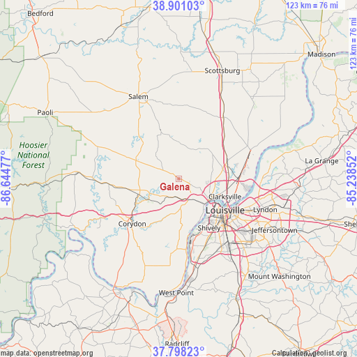
Galena GPS coordinates[2]
38° 21' 6.228" North, 85° 56' 29.904" West
| Map corner | latitude | longitude |
|---|---|---|
| Upper-left | 38.90103°, | -86.64477° |
| Center: | 38.35173°, | -85.94164° |
| Lower-right: | 37.79823°, | -85.23852° |
| Map W x H: | 122.6×122.6 km | = 76.2×76.2mi |
| max Lat: | 71.29058° ⇑59.6% North |
| Galena: | 38.35173° |
| min Lat: | ⇓40.4% South 19.06759° |
| min Long | Galena | max Long |
| -171.73463° | -85.94164° | -66.98998° |
| W 53.1%⇐ | ⇒46.9% E |
Elevation
Elevation of Galena is 251 m = 823 ft, and this is 43.8 m = 144 ft below average elevation for this country.
| Max E: |
3189 m = 10463 ft | 37.4% |
| Avg. | 294.8 m = 967 ft | |
| Galena | 251 m = 823 ft | |
Min E: |
-60 m = -197 ft | 62.6% |
See also: United States elevation on elevation.city.
Geographical zone
Galena is located in North temperate zone (between Tropic of Cancer and the Arctic Circle). Distance of this Northern Tropic circle is 1658.4 km =1030.5 mi to South.| Distance of | km | miles | from Galena |
|---|---|---|---|
| North Pole | 5742.7 | 3568.3 | to North |
| Arctic Circle | 3136.9 | 1949.2 | to North |
| Tropic Cancer | 1658.4 | 1030.5 | to South |
| Equator | 4264.3 | 2649.7 | to South |


Nearby cities:
15 places around Galena: (largest is in red/bold)
• Borden
12.8 km =8 mi,  358°
358°
• Clarksville
17 km =10.6 mi,  111°
111°
• Georgetown
7 km =4.3 mi,  204°
204°
• Greenville
4.5 km =2.8 mi,  300°
300°
• Jeffersonville
19.7 km =12.2 mi, 114°
• Lanesville
13.3 km =8.3 mi, 196°
• Louisville
19.2 km =11.9 mi,  124°
124°
• Memphis
21.5 km =13.4 mi,  46°
46°
• New Albany
12.6 km =7.8 mi,  125°
125°
• New Pekin
18.3 km =11.4 mi,  338°
338°
• New Salisbury
14 km =8.7 mi,  252°
252°
• Palmyra
15.9 km =9.9 mi,  293°
293°
• Saint Dennis
20 km =12.4 mi,  155°
155°
• Sellersburg
17.1 km =10.6 mi,  72°
72°
• Shively
19.8 km =12.3 mi,  148°
148°
Sources, notices
• [Note1] Compared only with cities in United States existing in our database
• [Src1] Map data: © OpenStreetMap contributors (CC-BY-SA)
• [Src2] Other city data from geonames.org with taken over terms of usage.
• [Src3] Geographical zone / Annual Mean Temperature by Robert A. Rohde @ Wikipedia
