Lanesville geodata
Lanesville (Indiana) is a populated place; located in United States in America/Kentucky/Louisville (GMT-4) time zone. With population of 569 people, there are 20047 cities with bigger population in this country. Compared to other cities in United States, 60.4% of cities are located further ↑North; 52.9% of cities are located further ←West and 53.9% of cities have lower elevation than Lanesville. Note1


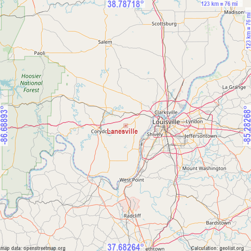
Lanesville GPS coordinates[2]
38° 14' 13.236" North, 85° 59' 8.88" West
| Map corner | latitude | longitude |
|---|---|---|
| Upper-left | 38.78718°, | -86.68893° |
| Center: | 38.23701°, | -85.9858° |
| Lower-right: | 37.68264°, | -85.28268° |
| Map W x H: | 122.8×122.8 km | = 76.3×76.3mi |
| max Lat: | 71.29058° ⇑60.4% North |
| Lanesville: | 38.23701° |
| min Lat: | ⇓39.6% South 19.06759° |
| min Long | Lanesville | max Long |
| -171.73463° | -85.9858° | -66.98998° |
| W 52.9%⇐ | ⇒47.1% E |
Elevation
Elevation of Lanesville is 214 m = 702 ft, and this is 80.8 m = 265 ft below average elevation for this country.
| Max E: |
3189 m = 10463 ft | 46.1% |
| Avg. | 294.8 m = 967 ft | |
| Lanesville | 214 m = 702 ft | |
Min E: |
-60 m = -197 ft | 53.9% |
See also: United States elevation on elevation.city.
Geographical zone
Lanesville is located in North temperate zone (between Tropic of Cancer and the Arctic Circle). Distance of this Northern Tropic circle is 1645.6 km =1022.5 mi to South.| Distance of | km | miles | from Lanesville |
|---|---|---|---|
| North Pole | 5755.5 | 3576.3 | to North |
| Arctic Circle | 3149.6 | 1957.1 | to North |
| Tropic Cancer | 1645.6 | 1022.5 | to South |
| Equator | 4251.6 | 2641.8 | to South |


Nearby cities:
15 places around Lanesville: (largest is in red/bold)
• Clarksville
20.8 km =12.9 mi,  71°
71°
• Corydon
12.2 km =7.6 mi,  256°
256°
• Galena
13.3 km =8.3 mi,  16°
16°
• Georgetown
6.5 km =4 mi,  7°
7°
• Greenville
15.1 km =9.4 mi,  359°
359°
• Jeffersonville
22.2 km =13.8 mi,  78°
78°
• Louisville
19.9 km =12.4 mi, 84°
• New Albany
15.1 km =9.4 mi, 69°
• New Salisbury
12.8 km =8 mi,  311°
311°
• Palmyra
21.9 km =13.6 mi,  330°
330°
• Parkway Village
21.6 km =13.4 mi,  97°
97°
• Pleasure Ridge Park
15.1 km =9.4 mi,  132°
132°
• Saint Dennis
13.4 km =8.3 mi,  113°
113°
• Shively
14.8 km =9.2 mi, 106°
• Valley Station
17.3 km =10.7 mi,  144°
144°
Sources, notices
• [Note1] Compared only with cities in United States existing in our database
• [Src1] Map data: © OpenStreetMap contributors (CC-BY-SA)
• [Src2] Other city data from geonames.org with taken over terms of usage.
• [Src3] Geographical zone / Annual Mean Temperature by Robert A. Rohde @ Wikipedia
