Shelbyville geodata
Shelbyville (Indiana) is a seat of a second-order administrative division; located in United States in America/Indiana/Indianapolis (GMT-4) time zone. With population of 19,133 people, there are 2631 cities with bigger population in this country. Compared to other cities in United States, 50.7% of cities are located further ↑North; 53.5% of cities are located further ←West and 58.8% of cities have lower elevation than Shelbyville. Note1


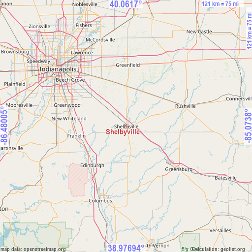
Shelbyville GPS coordinates[2]
39° 31' 17.184" North, 85° 46' 36.912" West
| Map corner | latitude | longitude |
|---|---|---|
| Upper-left | 40.0617°, | -86.48005° |
| Center: | 39.52144°, | -85.77692° |
| Lower-right: | 38.97694°, | -85.0738° |
| Map W x H: | 120.6×120.6 km | = 74.9×74.9mi |
| max Lat: | 71.29058° ⇑50.7% North |
| Shelbyville: | 39.52144° |
| min Lat: | ⇓49.3% South 19.06759° |
| min Long | Shelbyville | max Long |
| -171.73463° | -85.77692° | -66.98998° |
| W 53.5%⇐ | ⇒46.5% E |
Elevation
Elevation of Shelbyville is 234 m = 768 ft, and this is 60.8 m = 199 ft below average elevation for this country.
| Max E: |
3189 m = 10463 ft | 41.2% |
| Avg. | 294.8 m = 967 ft | |
| Shelbyville | 234 m = 768 ft | |
Min E: |
-60 m = -197 ft | 58.8% |
See also: United States elevation on elevation.city.
Geographical zone
Shelbyville is located in North temperate zone (between Tropic of Cancer and the Arctic Circle). Distance of this Northern Tropic circle is 1788.5 km =1111.3 mi to South.| Distance of | km | miles | from Shelbyville |
|---|---|---|---|
| North Pole | 5612.7 | 3487.6 | to North |
| Arctic Circle | 3006.8 | 1868.3 | to North |
| Tropic Cancer | 1788.5 | 1111.3 | to South |
| Equator | 4394.4 | 2730.6 | to South |


Nearby cities:
15 places around Shelbyville: (largest is in red/bold)
• Carthage
29.8 km =18.5 mi,  36°
36°
• Edinburgh
24.7 km =15.3 mi,  221°
221°
• Fairland
10.3 km =6.4 mi,  313°
313°
• Franklin
24.3 km =15.1 mi,  259°
259°
• Geneva
15.2 km =9.4 mi,  161°
161°
• Greenfield
29.3 km =18.2 mi,  1°
1°
• Hope
24.2 km =15 mi,  178°
178°
• Milroy
26.5 km =16.5 mi,  95°
95°
• Morristown
18.2 km =11.3 mi,  21°
21°
• New Palestine
24.3 km =15.1 mi,  336°
336°
• New Whiteland
27.6 km =17.1 mi,  278°
278°
• Saint Paul
16.4 km =10.2 mi,  129°
129°
• Taylorsville
29.2 km =18.1 mi,  210°
210°
• Waldron
12.1 km =7.5 mi, 128°
• Whiteland
26.2 km =16.3 mi, 276°
Sources, notices
• [Note1] Compared only with cities in United States existing in our database
• [Src1] Map data: © OpenStreetMap contributors (CC-BY-SA)
• [Src2] Other city data from geonames.org with taken over terms of usage.
• [Src3] Geographical zone / Annual Mean Temperature by Robert A. Rohde @ Wikipedia
