Huntingburg geodata
Huntingburg (Indiana) is a populated place; located in United States in America/Indiana/Vincennes (GMT-4) time zone. With population of 6,035 people, there are 6379 cities with bigger population in this country. Compared to other cities in United States, 59.9% of cities are located further ↑North; 50.4% of cities are located further ←West and 60.9% of cities have higher elevation than Huntingburg. Note1


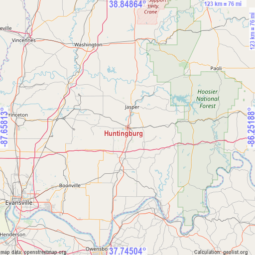
Huntingburg GPS coordinates[2]
38° 17' 56.184" North, 86° 57' 18" West
| Map corner | latitude | longitude |
|---|---|---|
| Upper-left | 38.84864°, | -87.65813° |
| Center: | 38.29894°, | -86.955° |
| Lower-right: | 37.74504°, | -86.25188° |
| Map W x H: | 122.7×122.7 km | = 76.2×76.2mi |
| max Lat: | 71.29058° ⇑59.9% North |
| Huntingburg: | 38.29894° |
| min Lat: | ⇓40.1% South 19.06759° |
| min Long | Huntingburg | max Long |
| -171.73463° | -86.955° | -66.98998° |
| W 50.4%⇐ | ⇒49.6% E |
Elevation
Elevation of Huntingburg is 150 m = 492 ft, and this is 144.8 m = 475 ft below average elevation for this country.
| Max E: |
3189 m = 10463 ft | 60.9% |
| Avg. | 294.8 m = 967 ft | |
| Huntingburg | 150 m = 492 ft | |
Min E: |
-60 m = -197 ft | 39.1% |
See also: United States elevation on elevation.city.
Geographical zone
Huntingburg is located in North temperate zone (between Tropic of Cancer and the Arctic Circle). Distance of this Northern Tropic circle is 1652.5 km =1026.8 mi to South.| Distance of | km | miles | from Huntingburg |
|---|---|---|---|
| North Pole | 5748.6 | 3572 | to North |
| Arctic Circle | 3142.7 | 1952.8 | to North |
| Tropic Cancer | 1652.5 | 1026.8 | to South |
| Equator | 4258.4 | 2646 | to South |


Nearby cities:
15 places around Huntingburg: (largest is in red/bold)
• Boonville
39.4 km =24.5 mi,  225°
225°
• Dale
14.8 km =9.2 mi,  191°
191°
• Ferdinand
11.6 km =7.2 mi,  135°
135°
• French Lick
40.3 km =25 mi,  46°
46°
• Grandview
40.7 km =25.3 mi,  183°
183°
• Holland
9.2 km =5.7 mi, 230°
• Jasper
10.5 km =6.5 mi,  11°
11°
• Lewisport
40.5 km =25.2 mi,  173°
173°
• Lynnville
31.9 km =19.8 mi,  249°
249°
• Oakland City
34.3 km =21.3 mi,  277°
277°
• Petersburg
35.4 km =22 mi,  307°
307°
• Saint Meinrad
19.1 km =11.9 mi, 138°
• Santa Claus
20.2 km =12.6 mi, 169°
• Tell City
42 km =26.1 mi,  157°
157°
• Winslow
24.3 km =15.1 mi,  292°
292°
Sources, notices
• [Note1] Compared only with cities in United States existing in our database
• [Src1] Map data: © OpenStreetMap contributors (CC-BY-SA)
• [Src2] Other city data from geonames.org with taken over terms of usage.
• [Src3] Geographical zone / Annual Mean Temperature by Robert A. Rohde @ Wikipedia
