Lynnville geodata
Lynnville (Indiana) is a populated place; located in United States in America/Chicago (GMT-5) time zone. With population of 921 people, there are 16858 cities with bigger population in this country. Compared to other cities in United States, 60.7% of cities are located further ↑North; 50.3% of cities are located further →East and 62.6% of cities have higher elevation than Lynnville. Note1


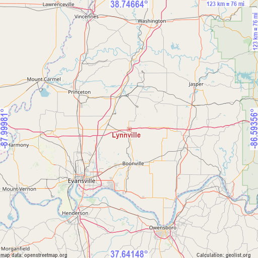
Lynnville GPS coordinates[2]
38° 11' 46.176" North, 87° 17' 48.048" West
| Map corner | latitude | longitude |
|---|---|---|
| Upper-left | 38.74664°, | -87.99981° |
| Center: | 38.19616°, | -87.29668° |
| Lower-right: | 37.64148°, | -86.59356° |
| Map W x H: | 122.9×122.9 km | = 76.4×76.4mi |
| max Lat: | 71.29058° ⇑60.7% North |
| Lynnville: | 38.19616° |
| min Lat: | ⇓39.3% South 19.06759° |
| min Long | Lynnville | max Long |
| -171.73463° | -87.29668° | -66.98998° |
| W 49.7%⇐ | ⇒50.3% E |
Elevation
Elevation of Lynnville is 141 m = 463 ft, and this is 153.8 m = 505 ft below average elevation for this country.
| Max E: |
3189 m = 10463 ft | 62.6% |
| Avg. | 294.8 m = 967 ft | |
| Lynnville | 141 m = 463 ft | |
Min E: |
-60 m = -197 ft | 37.4% |
See also: United States elevation on elevation.city.
Geographical zone
Lynnville is located in North temperate zone (between Tropic of Cancer and the Arctic Circle). Distance of this Northern Tropic circle is 1641.1 km =1019.7 mi to South.| Distance of | km | miles | from Lynnville |
|---|---|---|---|
| North Pole | 5760 | 3579.1 | to North |
| Arctic Circle | 3154.2 | 1959.9 | to North |
| Tropic Cancer | 1641.1 | 1019.7 | to South |
| Equator | 4247 | 2639 | to South |


Nearby cities:
15 places around Lynnville: (largest is in red/bold)
• Boonville
16.5 km =10.3 mi,  173°
173°
• Chandler
18.3 km =11.4 mi,  199°
199°
• Dale
27 km =16.8 mi,  96°
96°
• Darmstadt
26.9 km =16.7 mi,  246°
246°
• Elberfeld
13.9 km =8.6 mi, 253°
• Fort Branch
25.6 km =15.9 mi,  283°
283°
• Haubstadt
24.3 km =15.1 mi,  272°
272°
• Highland
29.8 km =18.5 mi,  234°
234°
• Holland
23.4 km =14.5 mi,  76°
76°
• Huntingburg
31.9 km =19.8 mi,  69°
69°
• Melody Hill
26.9 km =16.7 mi, 225°
• Newburgh
29.6 km =18.4 mi, 198°
• Oakland City
16.4 km =10.2 mi,  345°
345°
• Princeton
29.5 km =18.3 mi,  306°
306°
• Winslow
22 km =13.7 mi,  19°
19°
Sources, notices
• [Note1] Compared only with cities in United States existing in our database
• [Src1] Map data: © OpenStreetMap contributors (CC-BY-SA)
• [Src2] Other city data from geonames.org with taken over terms of usage.
• [Src3] Geographical zone / Annual Mean Temperature by Robert A. Rohde @ Wikipedia
