Holland geodata
Holland (Indiana) is a populated place; located in United States in America/Indiana/Vincennes (GMT-4) time zone. With population of 618 people, there are 19489 cities with bigger population in this country. Compared to other cities in United States, 60.3% of cities are located further ↑North; 50.2% of cities are located further ←West and 58% of cities have higher elevation than Holland. Note1


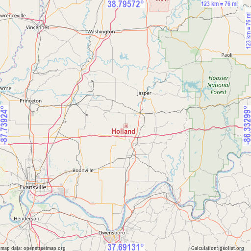
Holland GPS coordinates[2]
38° 14' 44.196" North, 87° 2' 9.996" West
| Map corner | latitude | longitude |
|---|---|---|
| Upper-left | 38.79572°, | -87.73924° |
| Center: | 38.24561°, | -87.03611° |
| Lower-right: | 37.69131°, | -86.33299° |
| Map W x H: | 122.8×122.8 km | = 76.3×76.3mi |
| max Lat: | 71.29058° ⇑60.3% North |
| Holland: | 38.24561° |
| min Lat: | ⇓39.7% South 19.06759° |
| min Long | Holland | max Long |
| -171.73463° | -87.03611° | -66.98998° |
| W 50.2%⇐ | ⇒49.8% E |
Elevation
Elevation of Holland is 165 m = 541 ft, and this is 129.8 m = 426 ft below average elevation for this country.
| Max E: |
3189 m = 10463 ft | 58% |
| Avg. | 294.8 m = 967 ft | |
| Holland | 165 m = 541 ft | |
Min E: |
-60 m = -197 ft | 42% |
See also: United States elevation on elevation.city.
Geographical zone
Holland is located in North temperate zone (between Tropic of Cancer and the Arctic Circle). Distance of this Northern Tropic circle is 1646.6 km =1023.1 mi to South.| Distance of | km | miles | from Holland |
|---|---|---|---|
| North Pole | 5754.5 | 3575.7 | to North |
| Arctic Circle | 3148.7 | 1956.5 | to North |
| Tropic Cancer | 1646.6 | 1023.1 | to South |
| Equator | 4252.5 | 2642.4 | to South |


Nearby cities:
15 places around Holland: (largest is in red/bold)
• Boonville
30.2 km =18.8 mi,  223°
223°
• Chandler
36.8 km =22.9 mi,  232°
232°
• Dale
9.4 km =5.8 mi,  154°
154°
• Elberfeld
37.3 km =23.2 mi,  255°
255°
• Ferdinand
15.4 km =9.6 mi,  99°
99°
• Grandview
35 km =21.7 mi,  172°
172°
• Huntingburg
9.2 km =5.7 mi,  50°
50°
• Jasper
18.6 km =11.6 mi,  29°
29°
• Lewisport
36.3 km =22.6 mi,  161°
161°
• Lynnville
23.4 km =14.5 mi, 256°
• Oakland City
28.9 km =18 mi,  290°
290°
• Petersburg
34.6 km =21.5 mi,  322°
322°
• Saint Meinrad
21.5 km =13.4 mi,  112°
112°
• Santa Claus
17.6 km =10.9 mi,  142°
142°
• Winslow
21.6 km =13.4 mi,  314°
314°
Sources, notices
• [Note1] Compared only with cities in United States existing in our database
• [Src1] Map data: © OpenStreetMap contributors (CC-BY-SA)
• [Src2] Other city data from geonames.org with taken over terms of usage.
• [Src3] Geographical zone / Annual Mean Temperature by Robert A. Rohde @ Wikipedia
