Montezuma geodata
Montezuma (Indiana) is a populated place; located in United States in America/Indiana/Indianapolis (GMT-4) time zone. With population of 983 people, there are 16389 cities with bigger population in this country. Compared to other cities in United States, 51.4% of cities are located further ↓South; 50.5% of cities are located further →East and 59% of cities have higher elevation than Montezuma. Note1


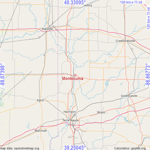
Montezuma GPS coordinates[2]
39° 47' 34.152" North, 87° 22' 15.06" West
| Map corner | latitude | longitude |
|---|---|---|
| Upper-left | 40.33095°, | -88.07398° |
| Center: | 39.79282°, | -87.37085° |
| Lower-right: | 39.25045°, | -86.66773° |
| Map W x H: | 120.1×120.1 km | = 74.6×74.6mi |
| max Lat: | 71.29058° ⇑48.6% North |
| Montezuma: | 39.79282° |
| min Lat: | ⇓51.4% South 19.06759° |
| min Long | Montezuma | max Long |
| -171.73463° | -87.37085° | -66.98998° |
| W 49.5%⇐ | ⇒50.5% E |
Elevation
Elevation of Montezuma is 160 m = 525 ft, and this is 134.8 m = 442 ft below average elevation for this country.
| Max E: |
3189 m = 10463 ft | 59% |
| Avg. | 294.8 m = 967 ft | |
| Montezuma | 160 m = 525 ft | |
Min E: |
-60 m = -197 ft | 41% |
See also: United States elevation on elevation.city.
Geographical zone
Montezuma is located in North temperate zone (between Tropic of Cancer and the Arctic Circle). Distance of this Northern Tropic circle is 1818.6 km =1130 mi to South.| Distance of | km | miles | from Montezuma |
|---|---|---|---|
| North Pole | 5582.5 | 3468.8 | to North |
| Arctic Circle | 2976.6 | 1849.6 | to North |
| Tropic Cancer | 1818.6 | 1130 | to South |
| Equator | 4424.5 | 2749.3 | to South |


Nearby cities:
15 places around Montezuma: (largest is in red/bold)
• Cayuga
18.9 km =11.7 mi,  336°
336°
• Chrisman
25.9 km =16.1 mi,  272°
272°
• Clinton
15.3 km =9.5 mi,  188°
188°
• Dana
10.7 km =6.6 mi,  278°
278°
• Fairview Park
13.1 km =8.1 mi,  197°
197°
• Georgetown
30.4 km =18.9 mi,  311°
311°
• Newport
10.7 km =6.6 mi, 342°
• North Terre Haute
29.5 km =18.3 mi,  178°
178°
• Ridge Farm
26.6 km =16.5 mi,  295°
295°
• Rockport
12.5 km =7.8 mi,  38°
38°
• Rockville
12.6 km =7.8 mi,  105°
105°
• Rosedale
20.3 km =12.6 mi,  158°
158°
• Saint Bernice
15.9 km =9.9 mi,  234°
234°
• Saint Mary-of-the-Woods
32.4 km =20.1 mi, 194°
• Tecumseh
25.9 km =16.1 mi, 189°
Sources, notices
• [Note1] Compared only with cities in United States existing in our database
• [Src1] Map data: © OpenStreetMap contributors (CC-BY-SA)
• [Src2] Other city data from geonames.org with taken over terms of usage.
• [Src3] Geographical zone / Annual Mean Temperature by Robert A. Rohde @ Wikipedia
