Cayuga geodata
Cayuga (Indiana) is a populated place; located in United States in America/Indiana/Indianapolis (GMT-4) time zone. With population of 1,118 people, there are 15581 cities with bigger population in this country. Compared to other cities in United States, 53% of cities are located further ↓South; 50.7% of cities are located further →East and 59.5% of cities have higher elevation than Cayuga. Note1


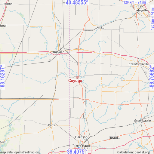
Cayuga GPS coordinates[2]
39° 56' 55.14" North, 87° 27' 35.064" West
| Map corner | latitude | longitude |
|---|---|---|
| Upper-left | 40.48555°, | -88.16287° |
| Center: | 39.94865°, | -87.45974° |
| Lower-right: | 39.4075°, | -86.75662° |
| Map W x H: | 119.9×119.9 km | = 74.5×74.5mi |
| max Lat: | 71.29058° ⇑47% North |
| Cayuga: | 39.94865° |
| min Lat: | ⇓53% South 19.06759° |
| min Long | Cayuga | max Long |
| -171.73463° | -87.45974° | -66.98998° |
| W 49.3%⇐ | ⇒50.7% E |
Elevation
Elevation of Cayuga is 157 m = 515 ft, and this is 137.8 m = 452 ft below average elevation for this country.
| Max E: |
3189 m = 10463 ft | 59.5% |
| Avg. | 294.8 m = 967 ft | |
| Cayuga | 157 m = 515 ft | |
Min E: |
-60 m = -197 ft | 40.5% |
See also: United States elevation on elevation.city.
Geographical zone
Cayuga is located in North temperate zone (between Tropic of Cancer and the Arctic Circle). Distance of this Northern Tropic circle is 1836 km =1140.8 mi to South.| Distance of | km | miles | from Cayuga |
|---|---|---|---|
| North Pole | 5565.2 | 3458.1 | to North |
| Arctic Circle | 2959.3 | 1838.8 | to North |
| Tropic Cancer | 1836 | 1140.8 | to South |
| Equator | 4441.9 | 2760.1 | to South |


Nearby cities:
15 places around Cayuga: (largest is in red/bold)
• Catlin
24.4 km =15.2 mi,  302°
302°
• Chrisman
24.4 km =15.2 mi,  228°
228°
• Covington
22.2 km =13.8 mi,  14°
14°
• Dana
15.9 km =9.9 mi,  190°
190°
• Danville
24.3 km =15.1 mi,  323°
323°
• Georgetown
15.3 km =9.5 mi,  281°
281°
• Montezuma
18.9 km =11.7 mi,  156°
156°
• Newport
8.4 km =5.2 mi,  148°
148°
• Ridge Farm
17.4 km =10.8 mi,  250°
250°
• Rockport
17.2 km =10.7 mi,  116°
116°
• Rockville
28.6 km =17.8 mi,  136°
136°
• Saint Bernice
27.1 km =16.8 mi, 191°
• Tilton
22.8 km =14.2 mi, 315°
• Veedersburg
24.8 km =15.4 mi,  42°
42°
• Westville
18.5 km =11.5 mi, 304°
Sources, notices
• [Note1] Compared only with cities in United States existing in our database
• [Src1] Map data: © OpenStreetMap contributors (CC-BY-SA)
• [Src2] Other city data from geonames.org with taken over terms of usage.
• [Src3] Geographical zone / Annual Mean Temperature by Robert A. Rohde @ Wikipedia
