Parkers Settlement geodata
Parkers Settlement (Indiana) is a populated place; located in United States in America/Chicago (GMT-5) time zone. With population of 711 people, there are 18575 cities with bigger population in this country. Compared to other cities in United States, 61.3% of cities are located further ↑North; 51.6% of cities are located further →East and 63.5% of cities have higher elevation than Parkers Settlement. Note1


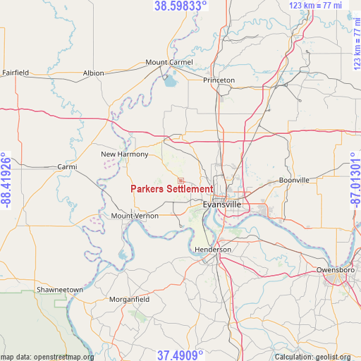
Parkers Settlement GPS coordinates[2]
38° 2' 48.156" North, 87° 42' 58.068" West
| Map corner | latitude | longitude |
|---|---|---|
| Upper-left | 38.59833°, | -88.41926° |
| Center: | 38.04671°, | -87.71613° |
| Lower-right: | 37.4909°, | -87.01301° |
| Map W x H: | 123.1×123.1 km | = 76.5×76.5mi |
| max Lat: | 71.29058° ⇑61.3% North |
| Parkers Settlement: | 38.04671° |
| min Lat: | ⇓38.7% South 19.06759° |
| min Long | Parkers Settlem | max Long |
| -171.73463° | -87.71613° | -66.98998° |
| W 48.4%⇐ | ⇒51.6% E |
Elevation
Elevation of Parkers Settlement is 136 m = 446 ft, and this is 158.8 m = 521 ft below average elevation for this country.
| Max E: |
3189 m = 10463 ft | 63.5% |
| Avg. | 294.8 m = 967 ft | |
| Parkers Settlement | 136 m = 446 ft | |
Min E: |
-60 m = -197 ft | 36.5% |
See also: United States elevation on elevation.city.
Geographical zone
Parkers Settlement is located in North temperate zone (between Tropic of Cancer and the Arctic Circle). Distance of this Northern Tropic circle is 1624.5 km =1009.4 mi to South.| Distance of | km | miles | from Parkers Settlement |
|---|---|---|---|
| North Pole | 5776.7 | 3589.5 | to North |
| Arctic Circle | 3170.8 | 1970.2 | to North |
| Tropic Cancer | 1624.5 | 1009.4 | to South |
| Equator | 4230.4 | 2628.6 | to South |


Nearby cities:
15 places around Parkers Settlement: (largest is in red/bold)
• Chandler
30.5 km =19 mi,  91°
91°
• Cynthiana
15.7 km =9.8 mi,  1°
1°
• Darmstadt
13.4 km =8.3 mi,  64°
64°
• Elberfeld
26.6 km =16.5 mi, 61°
• Evansville
16.2 km =10.1 mi,  119°
119°
• Fort Branch
25.6 km =15.9 mi,  27°
27°
• Haubstadt
21.5 km =13.4 mi,  35°
35°
• Henderson
25.9 km =16.1 mi,  154°
154°
• Highland
12.6 km =7.8 mi, 93°
• Melody Hill
17.7 km =11 mi,  97°
97°
• Mount Vernon
20.2 km =12.6 mi,  230°
230°
• New Harmony
21.3 km =13.2 mi,  295°
295°
• Newburgh
29.5 km =18.3 mi,  112°
112°
• Owensville
25.2 km =15.7 mi,  5°
5°
• Poseyville
14.9 km =9.3 mi,  336°
336°
Sources, notices
• [Note1] Compared only with cities in United States existing in our database
• [Src1] Map data: © OpenStreetMap contributors (CC-BY-SA)
• [Src2] Other city data from geonames.org with taken over terms of usage.
• [Src3] Geographical zone / Annual Mean Temperature by Robert A. Rohde @ Wikipedia
