Evansville geodata
Evansville (Indiana) is a seat of a second-order administrative division; located in United States in America/Chicago (GMT-5) time zone. With population of 119,943 people, there are 263 cities with bigger population in this country. Compared to other cities in United States, 61.8% of cities are located further ↑North; 50.9% of cities are located further →East and 66.9% of cities have higher elevation than Evansville. Note1
Administrative division(s):
- Level 1: Indiana
- Level 2: Vanderburgh County
- Level 3: Township of Pigeon


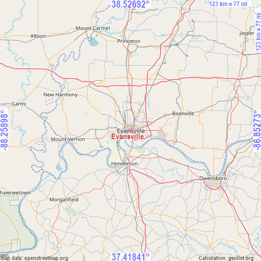
Evansville GPS coordinates[2]
37° 58' 29.136" North, 87° 33' 21.06" West
| Map corner | latitude | longitude |
|---|---|---|
| Upper-left | 38.52692°, | -88.25898° |
| Center: | 37.97476°, | -87.55585° |
| Lower-right: | 37.41841°, | -86.85273° |
| Map W x H: | 123.3×123.3 km | = 76.6×76.6mi |
| max Lat: | 71.29058° ⇑61.8% North |
| Evansville: | 37.97476° |
| min Lat: | ⇓38.2% South 19.06759° |
| min Long | Evansville | max Long |
| -171.73463° | -87.55585° | -66.98998° |
| W 49.1%⇐ | ⇒50.9% E |
Elevation
Elevation of Evansville is 118 m = 387 ft, and this is 176.8 m = 580 ft below average elevation for this country.
| Max E: |
3189 m = 10463 ft | 66.9% |
| Avg. | 294.8 m = 967 ft | |
| Evansville | 118 m = 387 ft | |
Min E: |
-60 m = -197 ft | 33.1% |
See also: Evansville elevation on elevation.city.
Geographical zone
Evansville is located in North temperate zone (between Tropic of Cancer and the Arctic Circle). Distance of this Northern Tropic circle is 1616.5 km =1004.4 mi to South.| Distance of | km | miles | from Evansville |
|---|---|---|---|
| North Pole | 5784.7 | 3594.4 | to North |
| Arctic Circle | 3178.8 | 1975.2 | to North |
| Tropic Cancer | 1616.5 | 1004.4 | to South |
| Equator | 4222.4 | 2623.7 | to South |


Nearby cities:
15 places around Evansville: (largest is in red/bold)
• Boonville
26 km =16.2 mi,  71°
71°
• Chandler
18.1 km =11.2 mi, 65°
• Corydon
28.8 km =17.9 mi,  206°
206°
• Cynthiana
27.2 km =16.9 mi,  330°
330°
• Darmstadt
14 km =8.7 mi,  351°
351°
• Elberfeld
22.6 km =14 mi,  24°
24°
• Hatfield
30.2 km =18.8 mi,  105°
105°
• Haubstadt
25.7 km =16 mi,  356°
356°
• Henderson
15.7 km =9.8 mi,  191°
191°
• Highland
7.4 km =4.6 mi, 348°
• Melody Hill
6.7 km =4.2 mi,  31°
31°
• Mount Vernon
30.1 km =18.7 mi,  260°
260°
• Newburgh
13.6 km =8.5 mi,  104°
104°
• Parkers Settlement
16.2 km =10.1 mi,  299°
299°
• Poseyville
29.4 km =18.3 mi,  317°
317°
Sources, notices
• [Note1] Compared only with cities in United States existing in our database
• [Src1] Map data: © OpenStreetMap contributors (CC-BY-SA)
• [Src2] Other city data from geonames.org with taken over terms of usage.
• [Src3] Geographical zone / Annual Mean Temperature by Robert A. Rohde @ Wikipedia
