Chandler geodata
Chandler (Indiana) is a populated place; located in United States in America/Chicago (GMT-5) time zone. With population of 3,385 people, there are 9014 cities with bigger population in this country. Compared to other cities in United States, 61.3% of cities are located further ↑North; 50.5% of cities are located further →East and 65.5% of cities have higher elevation than Chandler. Note1


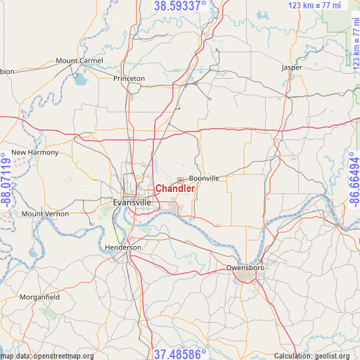
Chandler GPS coordinates[2]
38° 2' 30.156" North, 87° 22' 5.016" West
| Map corner | latitude | longitude |
|---|---|---|
| Upper-left | 38.59337°, | -88.07119° |
| Center: | 38.04171°, | -87.36806° |
| Lower-right: | 37.48586°, | -86.66494° |
| Map W x H: | 123.1×123.1 km | = 76.5×76.5mi |
| max Lat: | 71.29058° ⇑61.3% North |
| Chandler: | 38.04171° |
| min Lat: | ⇓38.7% South 19.06759° |
| min Long | Chandler | max Long |
| -171.73463° | -87.36806° | -66.98998° |
| W 49.5%⇐ | ⇒50.5% E |
Elevation
Elevation of Chandler is 126 m = 413 ft, and this is 168.8 m = 554 ft below average elevation for this country.
| Max E: |
3189 m = 10463 ft | 65.5% |
| Avg. | 294.8 m = 967 ft | |
| Chandler | 126 m = 413 ft | |
Min E: |
-60 m = -197 ft | 34.5% |
See also: United States elevation on elevation.city.
Geographical zone
Chandler is located in North temperate zone (between Tropic of Cancer and the Arctic Circle). Distance of this Northern Tropic circle is 1623.9 km =1009 mi to South.| Distance of | km | miles | from Chandler |
|---|---|---|---|
| North Pole | 5777.2 | 3589.8 | to North |
| Arctic Circle | 3171.3 | 1970.6 | to North |
| Tropic Cancer | 1623.9 | 1009 | to South |
| Equator | 4229.8 | 2628.3 | to South |


Nearby cities:
15 places around Chandler: (largest is in red/bold)
• Boonville
8.3 km =5.2 mi,  84°
84°
• Darmstadt
19.5 km =12.1 mi,  289°
289°
• Elberfeld
14.9 km =9.3 mi,  331°
331°
• Evansville
18.1 km =11.2 mi,  245°
245°
• Fort Branch
29.8 km =18.5 mi,  321°
321°
• Hatfield
20 km =12.4 mi,  140°
140°
• Haubstadt
25.6 km =15.9 mi, 315°
• Henderson
30 km =18.6 mi,  220°
220°
• Highland
18 km =11.2 mi,  269°
269°
• Lynnville
18.3 km =11.4 mi,  19°
19°
• Melody Hill
13.1 km =8.1 mi,  262°
262°
• Newburgh
11.3 km =7 mi,  196°
196°
• Oakland City
33.1 km =20.6 mi,  3°
3°
• Parkers Settlement
30.5 km =19 mi, 271°
• Rockport
33 km =20.5 mi,  122°
122°
Sources, notices
• [Note1] Compared only with cities in United States existing in our database
• [Src1] Map data: © OpenStreetMap contributors (CC-BY-SA)
• [Src2] Other city data from geonames.org with taken over terms of usage.
• [Src3] Geographical zone / Annual Mean Temperature by Robert A. Rohde @ Wikipedia
