Henderson geodata
Henderson (Kentucky) is a seat of a second-order administrative division; located in United States in America/Chicago (GMT-5) time zone. With population of 28,890 people, there are 1727 cities with bigger population in this country. Compared to other cities in United States, 62.5% of cities are located further ↑North; 51% of cities are located further →East and 66% of cities have higher elevation than Henderson. Note1


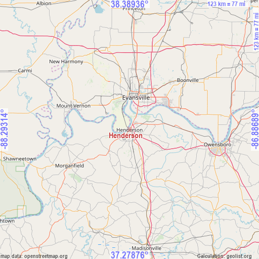
Henderson GPS coordinates[2]
37° 50' 10.14" North, 87° 35' 24.036" West
| Map corner | latitude | longitude |
|---|---|---|
| Upper-left | 38.38936°, | -88.29314° |
| Center: | 37.83615°, | -87.59001° |
| Lower-right: | 37.27876°, | -86.88689° |
| Map W x H: | 123.5×123.5 km | = 76.7×76.7mi |
| max Lat: | 71.29058° ⇑62.5% North |
| Henderson: | 37.83615° |
| min Lat: | ⇓37.5% South 19.06759° |
| min Long | Henderson | max Long |
| -171.73463° | -87.59001° | -66.98998° |
| W 49%⇐ | ⇒51% E |
Elevation
Elevation of Henderson is 123 m = 404 ft, and this is 171.8 m = 564 ft below average elevation for this country.
| Max E: |
3189 m = 10463 ft | 66% |
| Avg. | 294.8 m = 967 ft | |
| Henderson | 123 m = 404 ft | |
Min E: |
-60 m = -197 ft | 34% |
See also: United States elevation on elevation.city.
Geographical zone
Henderson is located in North temperate zone (between Tropic of Cancer and the Arctic Circle). Distance of this Northern Tropic circle is 1601.1 km =994.9 mi to South.| Distance of | km | miles | from Henderson |
|---|---|---|---|
| North Pole | 5800.1 | 3604 | to North |
| Arctic Circle | 3194.2 | 1984.8 | to North |
| Tropic Cancer | 1601.1 | 994.9 | to South |
| Equator | 4207 | 2614.1 | to South |


Nearby cities:
15 places around Henderson: (largest is in red/bold)
• Breckinridge Center
29.4 km =18.3 mi,  234°
234°
• Chandler
30 km =18.6 mi,  40°
40°
• Corydon
14.4 km =8.9 mi,  224°
224°
• Darmstadt
29.3 km =18.2 mi,  1°
1°
• Evansville
15.7 km =9.8 mi,  11°
11°
• Hatfield
32.9 km =20.4 mi,  77°
77°
• Highland
22.7 km =14.1 mi, 3°
• Melody Hill
22.1 km =13.7 mi,  17°
17°
• Morganfield
33.4 km =20.8 mi,  239°
239°
• Mount Vernon
28.8 km =17.9 mi,  291°
291°
• Newburgh
20.2 km =12.6 mi,  53°
53°
• Parkers Settlement
25.9 km =16.1 mi,  334°
334°
• Robards
18.4 km =11.4 mi,  168°
168°
• Sebree
26 km =16.2 mi, 168°
• Uniontown
30.7 km =19.1 mi,  257°
257°
Sources, notices
• [Note1] Compared only with cities in United States existing in our database
• [Src1] Map data: © OpenStreetMap contributors (CC-BY-SA)
• [Src2] Other city data from geonames.org with taken over terms of usage.
• [Src3] Geographical zone / Annual Mean Temperature by Robert A. Rohde @ Wikipedia
