Newburgh geodata
Newburgh (Indiana) is a populated place; located in United States in America/Chicago (GMT-5) time zone. With population of 3,277 people, there are 9187 cities with bigger population in this country. Compared to other cities in United States, 61.9% of cities are located further ↑North; 50.6% of cities are located further →East and 66.9% of cities have higher elevation than Newburgh. Note1


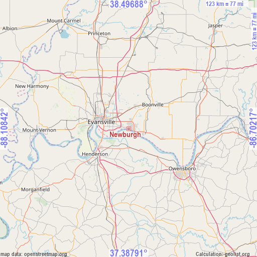
Newburgh GPS coordinates[2]
37° 56' 40.164" North, 87° 24' 19.044" West
| Map corner | latitude | longitude |
|---|---|---|
| Upper-left | 38.49688°, | -88.10842° |
| Center: | 37.94449°, | -87.40529° |
| Lower-right: | 37.38791°, | -86.70217° |
| Map W x H: | 123.3×123.3 km | = 76.6×76.6mi |
| max Lat: | 71.29058° ⇑61.9% North |
| Newburgh: | 37.94449° |
| min Lat: | ⇓38.1% South 19.06759° |
| min Long | Newburgh | max Long |
| -171.73463° | -87.40529° | -66.98998° |
| W 49.4%⇐ | ⇒50.6% E |
Elevation
Elevation of Newburgh is 118 m = 387 ft, and this is 176.8 m = 580 ft below average elevation for this country.
| Max E: |
3189 m = 10463 ft | 66.9% |
| Avg. | 294.8 m = 967 ft | |
| Newburgh | 118 m = 387 ft | |
Min E: |
-60 m = -197 ft | 33.1% |
See also: United States elevation on elevation.city.
Geographical zone
Newburgh is located in North temperate zone (between Tropic of Cancer and the Arctic Circle). Distance of this Northern Tropic circle is 1613.1 km =1002.3 mi to South.| Distance of | km | miles | from Newburgh |
|---|---|---|---|
| North Pole | 5788 | 3596.5 | to North |
| Arctic Circle | 3182.1 | 1977.3 | to North |
| Tropic Cancer | 1613.1 | 1002.3 | to South |
| Equator | 4219 | 2621.6 | to South |


Nearby cities:
15 places around Newburgh: (largest is in red/bold)
• Boonville
16.4 km =10.2 mi,  44°
44°
• Chandler
11.3 km =7 mi,  16°
16°
• Darmstadt
23 km =14.3 mi,  318°
318°
• Elberfeld
24.2 km =15 mi,  351°
351°
• Evansville
13.6 km =8.5 mi,  284°
284°
• Hatfield
16.6 km =10.3 mi,  106°
106°
• Haubstadt
32.5 km =20.2 mi,  332°
332°
• Henderson
20.2 km =12.6 mi,  233°
233°
• Highland
18.1 km =11.2 mi,  305°
305°
• Lynnville
29.6 km =18.4 mi, 18°
• Melody Hill
13.3 km =8.3 mi, 313°
• Owensboro
31.9 km =19.8 mi,  126°
126°
• Parkers Settlement
29.5 km =18.3 mi,  292°
292°
• Robards
32.5 km =20.2 mi,  202°
202°
• Rockport
32 km =19.9 mi,  102°
102°
Sources, notices
• [Note1] Compared only with cities in United States existing in our database
• [Src1] Map data: © OpenStreetMap contributors (CC-BY-SA)
• [Src2] Other city data from geonames.org with taken over terms of usage.
• [Src3] Geographical zone / Annual Mean Temperature by Robert A. Rohde @ Wikipedia
