Vassar geodata
Vassar (Kansas) is a populated place; located in United States in America/Chicago (GMT-5) time zone. With population of 530 people, there are 20501 cities with bigger population in this country. Compared to other cities in United States, 57.8% of cities are located further ↑North; 72.6% of cities are located further →East and 78.6% of cities have lower elevation than Vassar. Note1


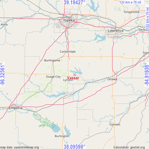
Vassar GPS coordinates[2]
38° 38' 50.028" North, 95° 37' 20.928" West
| Map corner | latitude | longitude |
|---|---|---|
| Upper-left | 39.19427°, | -96.32561° |
| Center: | 38.64723°, | -95.62248° |
| Lower-right: | 38.09598°, | -94.91936° |
| Map W x H: | 122.1×122.1 km | = 75.9×75.9mi |
| max Lat: | 71.29058° ⇑57.8% North |
| Vassar: | 38.64723° |
| min Lat: | ⇓42.2% South 19.06759° |
| min Long | Vassar | max Long |
| -171.73463° | -95.62248° | -66.98998° |
| W 27.4%⇐ | ⇒72.6% E |
Elevation
Elevation of Vassar is 341 m = 1119 ft, and this is 46.2 m = 152 ft above average elevation for this country.
| Max E: |
3189 m = 10463 ft | 21.4% |
| Vassar | 341 m 1119 ft | |
| Avg. | 294.8 m = 967 ft | |
Min E: |
-60 m = -197 ft | 78.6% |
See also: United States elevation on elevation.city.
Geographical zone
Vassar is located in North temperate zone (between Tropic of Cancer and the Arctic Circle). Distance of this Northern Tropic circle is 1691.3 km =1050.9 mi to South.| Distance of | km | miles | from Vassar |
|---|---|---|---|
| North Pole | 5709.9 | 3548 | to North |
| Arctic Circle | 3104 | 1928.7 | to North |
| Tropic Cancer | 1691.3 | 1050.9 | to South |
| Equator | 4297.2 | 2670.2 | to South |


Nearby cities:
15 places around Vassar: (largest is in red/bold)
• Auburn
33.3 km =20.7 mi,  329°
329°
• Baldwin City
40.4 km =25.1 mi,  69°
69°
• Burlingame
21.9 km =13.6 mi,  302°
302°
• Carbondale
19.9 km =12.4 mi,  343°
343°
• Lebo
32.5 km =20.2 mi,  218°
218°
• Lyndon
6.8 km =4.2 mi,  232°
232°
• Osage City
17.7 km =11 mi,  265°
265°
• Ottawa
31 km =19.3 mi,  96°
96°
• Overbrook
15.9 km =9.9 mi,  20°
20°
• Pomona
15.5 km =9.6 mi,  106°
106°
• Pomona
15.7 km =9.8 mi, 111°
• Scranton
18 km =11.2 mi, 326°
• Topeka
44.9 km =27.9 mi,  353°
353°
• Waverly
28.2 km =17.5 mi,  176°
176°
• Wellsville
47.6 km =29.6 mi,  80°
80°
Sources, notices
• [Note1] Compared only with cities in United States existing in our database
• [Src1] Map data: © OpenStreetMap contributors (CC-BY-SA)
• [Src2] Other city data from geonames.org with taken over terms of usage.
• [Src3] Geographical zone / Annual Mean Temperature by Robert A. Rohde @ Wikipedia
