Herington geodata
Herington (Kansas) is a populated place; located in United States in America/Chicago (GMT-5) time zone. With population of 2,396 people, there are 10862 cities with bigger population in this country. Compared to other cities in United States, 57.6% of cities are located further ↑North; 75.6% of cities are located further →East and 84.8% of cities have lower elevation than Herington. Note1


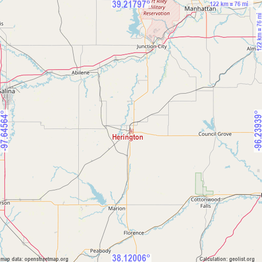
Herington GPS coordinates[2]
38° 40' 16.032" North, 96° 56' 33.036" West
| Map corner | latitude | longitude |
|---|---|---|
| Upper-left | 39.21797°, | -97.64564° |
| Center: | 38.67112°, | -96.94251° |
| Lower-right: | 38.12006°, | -96.23939° |
| Map W x H: | 122.1×122.1 km | = 75.9×75.9mi |
| max Lat: | 71.29058° ⇑57.6% North |
| Herington: | 38.67112° |
| min Lat: | ⇓42.4% South 19.06759° |
| min Long | Herington | max Long |
| -171.73463° | -96.94251° | -66.98998° |
| W 24.4%⇐ | ⇒75.6% E |
Elevation
Elevation of Herington is 419 m = 1375 ft, and this is 124.2 m = 407 ft above average elevation for this country.
| Max E: |
3189 m = 10463 ft | 15.2% |
| Herington | 419 m 1375 ft | |
| Avg. | 294.8 m = 967 ft | |
Min E: |
-60 m = -197 ft | 84.8% |
See also: United States elevation on elevation.city.
Geographical zone
Herington is located in North temperate zone (between Tropic of Cancer and the Arctic Circle). Distance of this Northern Tropic circle is 1693.9 km =1052.5 mi to South.| Distance of | km | miles | from Herington |
|---|---|---|---|
| North Pole | 5707.2 | 3546.3 | to North |
| Arctic Circle | 3101.3 | 1927.1 | to North |
| Tropic Cancer | 1693.9 | 1052.5 | to South |
| Equator | 4299.8 | 2671.8 | to South |


Nearby cities:
15 places around Herington: (largest is in red/bold)
• Abilene
36.1 km =22.4 mi,  319°
319°
• Canton
52.8 km =32.8 mi,  233°
233°
• Chapman
34.2 km =21.3 mi,  348°
348°
• Cottonwood Falls
48.1 km =29.9 mi,  133°
133°
• Council Grove
39.1 km =24.3 mi,  91°
91°
• Enterprise
29.9 km =18.6 mi,  329°
329°
• Fort Riley North
50.1 km =31.1 mi,  12°
12°
• Grandview Plaza
42 km =26.1 mi,  18°
18°
• Hillsboro
42.2 km =26.2 mi,  212°
212°
• Junction City
40.9 km =25.4 mi, 13°
• Marion
36.5 km =22.7 mi,  190°
190°
• Milford
55.3 km =34.4 mi,  2°
2°
• Ogden
53 km =32.9 mi, 22°
• Solomon
46.3 km =28.8 mi,  306°
306°
• White City
22.6 km =14 mi,  52°
52°
Sources, notices
• [Note1] Compared only with cities in United States existing in our database
• [Src1] Map data: © OpenStreetMap contributors (CC-BY-SA)
• [Src2] Other city data from geonames.org with taken over terms of usage.
• [Src3] Geographical zone / Annual Mean Temperature by Robert A. Rohde @ Wikipedia
