Abilene geodata
Abilene (Kansas) is a seat of a second-order administrative division; located in United States in America/Chicago (GMT-5) time zone. With population of 6,558 people, there are 6073 cities with bigger population in this country. Compared to other cities in United States, 55.7% of cities are located further ↑North; 76.3% of cities are located further →East and 80.5% of cities have lower elevation than Abilene. Note1


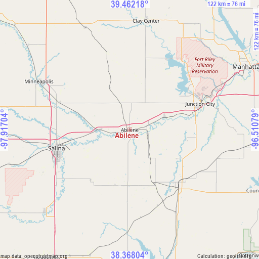
Abilene GPS coordinates[2]
38° 55' 1.992" North, 97° 12' 50.076" West
| Map corner | latitude | longitude |
|---|---|---|
| Upper-left | 39.46218°, | -97.91704° |
| Center: | 38.91722°, | -97.21391° |
| Lower-right: | 38.36804°, | -96.51079° |
| Map W x H: | 121.7×121.7 km | = 75.6×75.6mi |
| max Lat: | 71.29058° ⇑55.7% North |
| Abilene: | 38.91722° |
| min Lat: | ⇓44.3% South 19.06759° |
| min Long | Abilene | max Long |
| -171.73463° | -97.21391° | -66.98998° |
| W 23.7%⇐ | ⇒76.3% E |
Elevation
Elevation of Abilene is 358 m = 1175 ft, and this is 63.2 m = 207 ft above average elevation for this country.
| Max E: |
3189 m = 10463 ft | 19.5% |
| Abilene | 358 m 1175 ft | |
| Avg. | 294.8 m = 967 ft | |
Min E: |
-60 m = -197 ft | 80.5% |
See also: United States elevation on elevation.city.
Geographical zone
Abilene is located in North temperate zone (between Tropic of Cancer and the Arctic Circle). Distance of this Northern Tropic circle is 1721.3 km =1069.6 mi to South.| Distance of | km | miles | from Abilene |
|---|---|---|---|
| North Pole | 5679.9 | 3529.3 | to North |
| Arctic Circle | 3074 | 1910.1 | to North |
| Tropic Cancer | 1721.3 | 1069.6 | to South |
| Equator | 4327.2 | 2688.8 | to South |


Nearby cities:
15 places around Abilene: (largest is in red/bold)
• Bennington
35.2 km =21.9 mi,  290°
290°
• Chapman
17.6 km =10.9 mi,  69°
69°
• Clay Center
51.7 km =32.1 mi,  8°
8°
• Enterprise
8.5 km =5.3 mi,  100°
100°
• Fort Riley North
40.7 km =25.3 mi,  58°
58°
• Grandview Plaza
38.8 km =24.1 mi, 71°
• Herington
36.1 km =22.4 mi,  139°
139°
• Junction City
35.3 km =21.9 mi, 69°
• Milford
38.2 km =23.7 mi,  42°
42°
• Minneapolis
48.3 km =30 mi,  298°
298°
• Ogden
48.9 km =30.4 mi, 63°
• Salina
35.5 km =22.1 mi,  256°
256°
• Solomon
13.6 km =8.5 mi,  271°
271°
• Wakefield
37.5 km =23.3 mi,  28°
28°
• White City
43.5 km =27 mi,  108°
108°
Sources, notices
• [Note1] Compared only with cities in United States existing in our database
• [Src1] Map data: © OpenStreetMap contributors (CC-BY-SA)
• [Src2] Other city data from geonames.org with taken over terms of usage.
• [Src3] Geographical zone / Annual Mean Temperature by Robert A. Rohde @ Wikipedia
