White City geodata
White City (Kansas) is a populated place; located in United States in America/Chicago (GMT-5) time zone. With population of 581 people, there are 19902 cities with bigger population in this country. Compared to other cities in United States, 56.6% of cities are located further ↑North; 75% of cities are located further →East and 86.5% of cities have lower elevation than White City. Note1


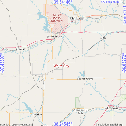
White City GPS coordinates[2]
38° 47' 44.016" North, 96° 44' 9.024" West
| Map corner | latitude | longitude |
|---|---|---|
| Upper-left | 39.34146°, | -97.43897° |
| Center: | 38.79556°, | -96.73584° |
| Lower-right: | 38.24545°, | -96.03272° |
| Map W x H: | 121.9×121.9 km | = 75.7×75.7mi |
| max Lat: | 71.29058° ⇑56.6% North |
| White City: | 38.79556° |
| min Lat: | ⇓43.4% South 19.06759° |
| min Long | White City | max Long |
| -171.73463° | -96.73584° | -66.98998° |
| W 25%⇐ | ⇒75% E |
Elevation
Elevation of White City is 453 m = 1486 ft, and this is 158.2 m = 519 ft above average elevation for this country.
| Max E: |
3189 m = 10463 ft | 13.5% |
| White City | 453 m 1486 ft | |
| Avg. | 294.8 m = 967 ft | |
Min E: |
-60 m = -197 ft | 86.5% |
See also: United States elevation on elevation.city.
Geographical zone
White City is located in North temperate zone (between Tropic of Cancer and the Arctic Circle). Distance of this Northern Tropic circle is 1707.7 km =1061.1 mi to South.| Distance of | km | miles | from White City |
|---|---|---|---|
| North Pole | 5693.4 | 3537.7 | to North |
| Arctic Circle | 3087.5 | 1918.5 | to North |
| Tropic Cancer | 1707.7 | 1061.1 | to South |
| Equator | 4313.7 | 2680.4 | to South |


Nearby cities:
15 places around White City: (largest is in red/bold)
• Abilene
43.5 km =27 mi,  288°
288°
• Alma
45.8 km =28.5 mi,  57°
57°
• Chapman
31.6 km =19.6 mi,  308°
308°
• Cottonwood Falls
50 km =31.1 mi,  160°
160°
• Council Grove
25.9 km =16.1 mi,  125°
125°
• Enterprise
35.1 km =21.8 mi, 289°
• Fort Riley North
35.7 km =22.2 mi,  349°
349°
• Grandview Plaza
26.4 km =16.4 mi, 349°
• Herington
22.6 km =14 mi,  232°
232°
• Junction City
27.2 km =16.9 mi,  342°
342°
• Manhattan
45.4 km =28.2 mi,  18°
18°
• Milford
44.2 km =27.5 mi, 339°
• Ogden
35.2 km =21.9 mi,  4°
4°
• Saint George
51.7 km =32.1 mi,  31°
31°
• Wakefield
52 km =32.3 mi,  333°
333°
Sources, notices
• [Note1] Compared only with cities in United States existing in our database
• [Src1] Map data: © OpenStreetMap contributors (CC-BY-SA)
• [Src2] Other city data from geonames.org with taken over terms of usage.
• [Src3] Geographical zone / Annual Mean Temperature by Robert A. Rohde @ Wikipedia
